
Municipal Profile
- Welcome to Kirkland
- Kirkland at a glance
- Major Development Projects
- Municipal Council
- Advisory Committees
- Services to suppliers
- Financial Profile
- Municipal Departments
The REM in Kirkland
Information Video No. 1
Information on the arrival of the REM in Kirkland
This information video produced in collaboration with CDPQ Infra aims to provide Kirkland citizens with information on the arrival of the REM in the West Island, and more particularly, on the work progress at the Kirkland Station.
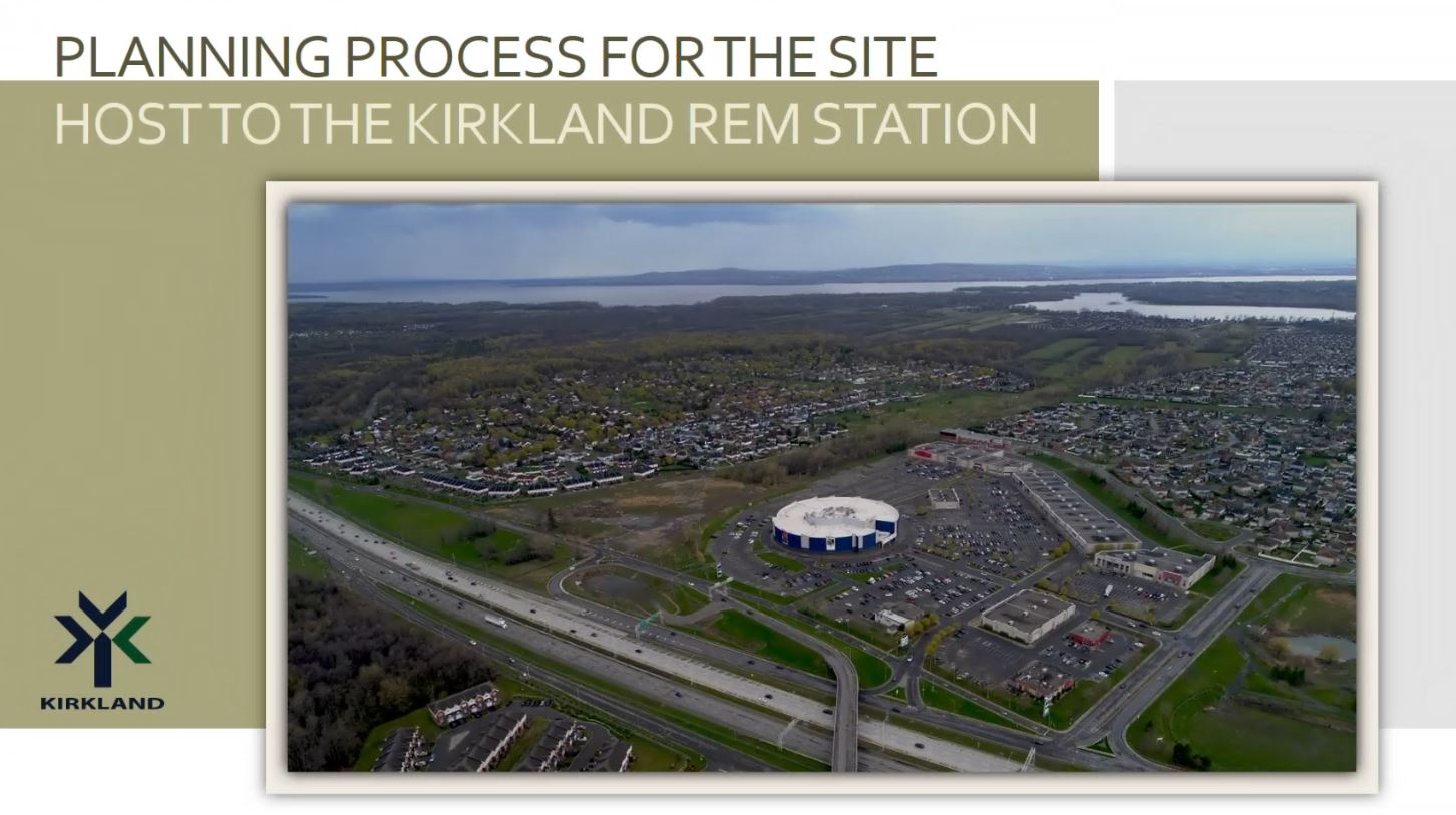
Information Video No. 2
Planning process of the Kirkland REM station site
This information video presents the planning process for the site host to the Kirkland REM Station. This presentation aims to provide a summary of the work accomplished since the last consultation activities and specifically address the strategic vision developed to requalify the site. It will also touch on the consultation and planning process that will structure the vision. This initiative is in keeping with the commitment of the Kirkland Town Council to inform citizens on the progress of this major project and to continue the dialogue with the citizens.
» To submit a question or a comment, click here
FAQ
In this section designed as evolving, you will find answers to the questions that have been sent to us regarding the requalification project and that are of public interest to the entire population. All the questions we receive are grouped according to the main topics that emerge, and reformulated according to the following themes:
Q. How will the City prevent REM users from parking on neighbouring streets near the station?
A. The Town of Kirkland will not tolerate on-street parking in neighbouring areas for REM users. Enforcement measures will be put in place to prevent this type of behavior, before the REM is put into service.
Q. Why is there no mention of the necessity for parking in the highlights of the comments made by residents at the 2017 participatory workshop?
A. This concern was not raised at the time as the initial project included a large incentive parking on the site, as well as a new road infrastructure to facilitate access to the parking area.
When it was announced that the incentive parking initially proposed would not be built on the site, the Kirkland Town Council took it upon itself to address the need expressed by citizens, and required that the Special Planning Program for the site incorporate parking spaces designated specifically for Kirkland citizens, near the station.
Q. How many parking spots will be reserved for Kirkland citizens using the REM?
A. We are presently finalizing an extensive traffic study to ensure the proposed number of parking spaces do not cause adverse traffic conditions. The main development orientations of the SPP currently provide for approximately 200 parking spaces reserved for Kirkland citizens using the REM.
Q. Will the STM adapt their bus routes to improve access to the REM stations servicing Kirkland residents?
A. Yes, the STM is presently reviewing their bus routes in preparation for the arrival of the REM in the West Island. However, final plans have yet to be confirmed.
In addition, the Town of Kirkland is currently developing its sustainable mobility plan to improve accessibility, safety, fluidity and cohabitation of the various modes of transportation on its territory, including public transit.
Q. Where will the parking area for Kirkland citizens who want to take the REM be located?
A. Considering that the site redevelopment project is at a very early stage, it is currently not possible to confirm the location of the future parking for the REM.
However, the SPP will include conditions requiring that parking for REM users be located on the RioCan site, within comfortable and functional walking distance of the REM station.
However, the UPP will include conditions requiring that parking be located on the RioCan site, within comfortable and functional walking distance of the REM station.
Q. What does it mean « to requalify »?
A. The requalification of a site can be defined as a change of vocation characterized by a change of activity aimed at redefining its role to ensure its viability.
In this case, the site covered by the SPP, whose vocation is entirely commercial, will be requalified so as to include a mix of residential and commercial uses integrating parks, green spaces and public places.
Q. Who is the author of the SPP?
A. Municipalities are responsible for the preparation, adoption and enforcement of their by-laws, including those pertaining to Urban Planning such as the Special Planning Program. In this instance, the Town of Kirkland mandated Provencher_Roy, a prominent architectural and urban planning firm, to assist its Urban Planning Department with the preparation of the SPP.
Q. Will there be opportunities for citizen participation in the development of the SPP?
A. As mentioned in the SPP information video, the consultation process began in 2017 with a participatory workshop attended by 280 citizens.
The current release of this information video coupled with the invitation extended to our citizens to submit their questions, comments and suggestions, is another step of the consultation process with citizens.
The next step will be a citizen information session and public consultation on more specific details of the Special Planning Program, in the spring of 2023.
Q. The information video refers to the site to be requalified, as a “strategic area”. Are there any other “strategic areas” within the Town’s boundaries?
A. Strategic areas within municipal boundaries are defined in a municipality’s Planning Program. The Town of Kirkland’s Planning Program dates back several years and requires a complete overhaul, which is currently underway, and will be subject to a public consultation with citizens in the spring. Other locations defined as “strategic areas” in the Town’s new Planning Program will be presented at this public consultation.
Q. Is the Colisée Kirkland cinema destined to disappear as part of the site’s requalification project? What about the other buildings on the site?
A. The decision whether to demolish an existing building, keep it in its current form, relocate it elsewhere on the site or give it a new configuration rests entirely with the owner of the site.
The SPP is a regulatory planning tool developed by the city to frame the desired vision for the redevelopment of this site, as defined by the city and its citizens. There will be no requirements to demolish any buildings, such as the cinema, in the SPP.
Once adopted by the Kirkland Town Council, the Special Planning Program will serve as a regulatory framework compelling the site owner to comply with its requirements and redevelop the site in accordance with the vision determined by the citizens and the municipality.
Q. How many residential/commercial units are considered on the site?
A. The number of residential/commercial units has not yet been determined. Different scenarios are currently under study.
In determining this number, several factors must be taken into account, such as the capacity of our infrastructure (road network and municipal services), the impact on traffic, the integration of the project into its environment and the economic viability of the project.
The scenario deemed optimal will be presented at the citizen information session and public consultation in the spring of 2023.
Q. Will the requalification project take place regardless of the presence on the site of an incentive parking for REM users?
A. As mentioned in the information video, once adopted by the Town Council, the SPP will serve as a regulatory framework compelling the site owner to comply with the SPP’s major development orientations, including, the requirement for any requalification project submitted to the Town, to include parking spaces reserved specifically for Kirkland citizens.
Q. Will the pedestrian and cycling network be improved in anticipation of the arrival of the requalification project and the REM station?
A. Yes, various options are currently being explored to create new pedestrian and cycling links that can connect to existing networks near the site. In addition, the city is currently developing its sustainable mobility plan that aims to create various secured connections to the REM station and the site to be requalified.
It should also be noted that the REM station will have bicycle parking facilities for cyclists wishing to go to the site or take the REM.
In addition, as mentioned in the presentation, the Lien de l’Ouest located along the western side of the site will include secure pedestrian and bicycle connections, as well as a new cycling and walking footbridge linking the south and north sides of Highway 40 and the future Grand Parc de l'Ouest on both sides of the highway.
Q. What is the timeline for the SPP and the project to requalify the site?
A. The city hopes to finalize and adopt the SPP in 2023. Once the regulatory tools and the SPP are adopted, the site owner will be able to present a concrete project that they wish to carry out, following the guidelines and legislative framework of the SPP.
Several authorizations are required before demolition and construction can actually begin (various approvals from the Planning Advisory Committee, the Demolition Committee and the Town Council, obtaining permits, etc.).
Depending on the willingness of the site owner, such a project could realistically be realized within 5 to 10 years.
Q. What are the planned car accesses for new residents on the site, visitors to the new businesses and the new public plaza, as well as for REM users?
A. The preliminary grid of proposed streets on the site is shown in the “Spatial Organization Concept” section of the SPP information video. Essentially, the new development will use the same access and egress points currently found at the RioCan Commercial Centre, with the difference that they will be public roadways instead of private access roads.
Given the current status of the SPP, it is too early to identify all of the road connections on the site. Further details will however be provided at the citizen information session and public consultation in the spring.
Q. What is the estimated impact of the project on traffic, roads and the environment? Will mitigation measures be required?
A. With regard to the estimated impact of the project on traffic and the road network, a traffic study considering different scenarios, is currently under analysis. This study aims to confirm the capacity of the existing road network to accommodate the project without affecting the quality of life of residents in the surrounding areas and without causing adverse traffic conditions. Upcoming reports will allow the Town to properly identify the issues at hand and define potential solutions.
For information purposes, mitigation measures can be implemented as part of a traffic study, if required. The findings of the traffic study will be presented at the citizen information session and public consultation this coming spring.
As concerns the environment, in order to ensure the harmonious integration of the project into neighboring areas, the planning of the SPP includes several sidewalks and cycling paths to promote active transportation and the use of the REM. In addition, an abundance of green spaces and the planting of a multitude of trees will transform the site, one of the West Island’s largest heat island, into an oasis of greenery.
Q. Why does the new « Lien de l’Ouest », better known as the A-440 right-of-way, not permit vehicular traffic?
A. The “Lien de l’Ouest” is a large green space that forms an integral part of the “Grand parc de l’Ouest”. It is destined to provide recreational activities and user-friendly links to this future major regional park. For information on the “Grand parc de l’Ouest”, click here.
The development of the “Lien de l’Ouest” into a corridor for pedestrians, cyclists and buses is the result of an agreement between the Ministry of Transport and Sustainable Mobility and the agglomeration of Montreal. This agreement was ratified in 2018 and does not include the presence of motor vehicles.
The Town of Kirkland ensures that every effort is made to create local connections between its local active transportation network (pedestrian and bicycle) and the “Lien de l’Ouest”.
Q. Will Jean-Yves Street reopen soon and will it remain open during the construction of the site’s redevelopment project?
A. On account of the ongoing work that CDPQi is conducting at the Kirkland REM station, it is unfortunately not possible to confirm the date at which Jean-Yves Street might be reopening.
During the construction period, the Town of Kirkland will take the necessary measures to ensure that all vehicular accesses, including Jean-Yves Street, remain open, safe and fluid.
This section will be updated on a regular basis to include answers to newly received questions on topics not previously addressed.
We have also received a number of very pertinent comments regarding the requalification project, which will be taken into account in the drafting of the Special Planning Program that will be presented at the spring information session and public consultation.
|
Please note: It has been agreed to postpone (date to be determined), the citizen information and public consultation meeting on the requalification project originally scheduled for last spring and to extend the online public consultation period. So there is still time to send us your questions, comments and suggestions so that we can take them into account in the planning of the host site for the Kirkland REM station. Please use the online form to do so. Thank you for your invaluable cooperation. Your participation is essential to the progress of this important project. |
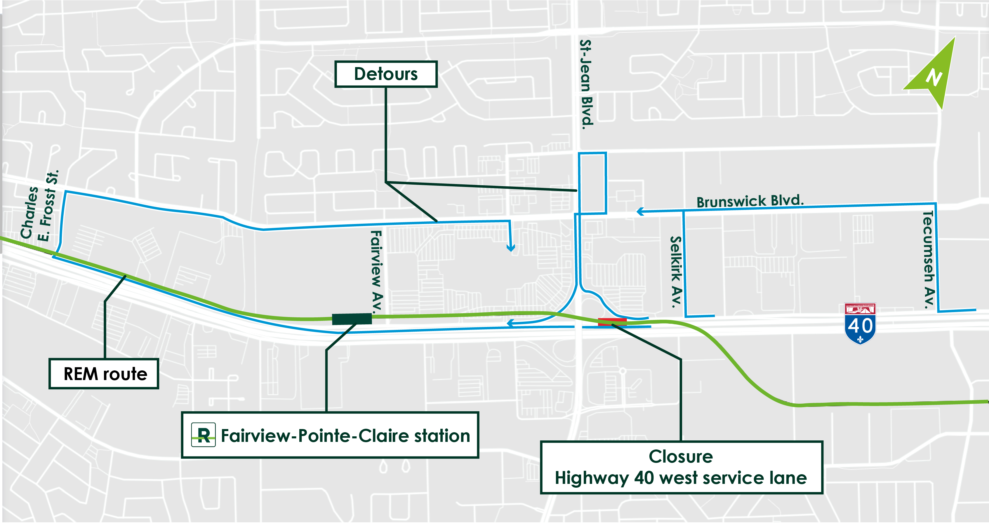
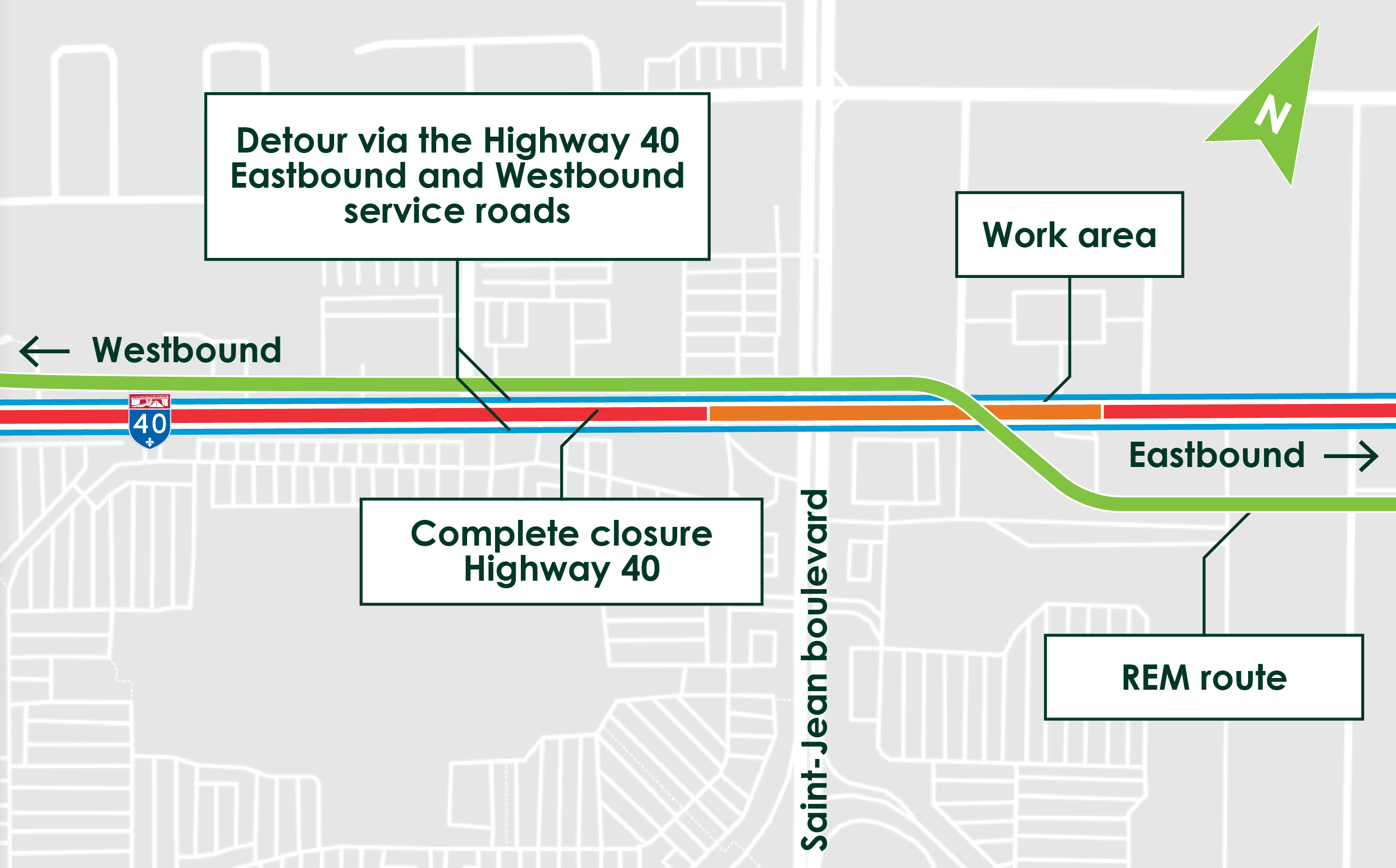
Works Info
Obstruction at the RioCan Kirkland Center between Ste-Marie Road and Jean-Yves Street
Date: Starting February 5, 2024, for a duration of six months
Where: RioCan Kirkland Center between Ste-Marie Road and Jean-Yves Street
To allow civil and electrical work to be carried out on the RioCan Kirkland Centre site, sections of the streets will be closed starting February 5, 2024. The work is scheduled to last six months and will require some detours. Please note that access to businesses will be maintained throughout the work.
The map below shows the work zone and detours for car drivers :
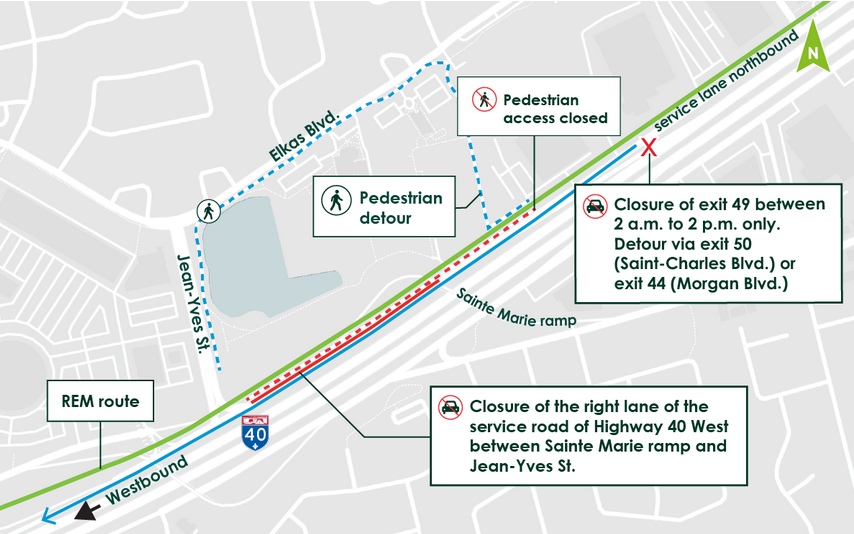
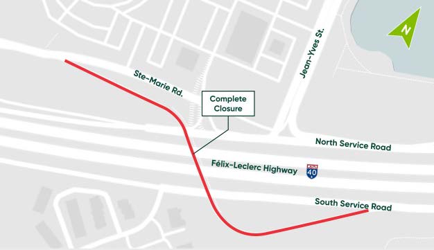
Connection of REM infrastructure to the storm water drainage system
Date: From March 14 to 28, 2023
Where: Along the service road, between the Chemin Sainte-Marie overpass and Jean Yves Street, Kirkland
Work to connect the REM infrastructure to the storm water drainage system will take place from March 14 to 28.
This work will cause several obstructions in the Kirkland sector near the future station.
Anticipated Obstructions and Mitigation Measures:
- Closure of Exit 49 from Highway 40 West from 2:00 am to 2:00 pm. The detour route will be via Exit 50 (St. Charles Blvd.) or Exit 44 (Morgan Blvd.);
- Continuous closure of the right lane of the Highway 40 West service road between the Sainte Marie Road on-ramp and Jean-Yves Street.
- Pedestrian Traffic : Sidewalk closure between the Sainte Marie Road service road ramp and Jean-Yves Street. The detour route is planned via a temporary pathway identified for this purpose.
The illustration below shows the barrier that will be put in place:
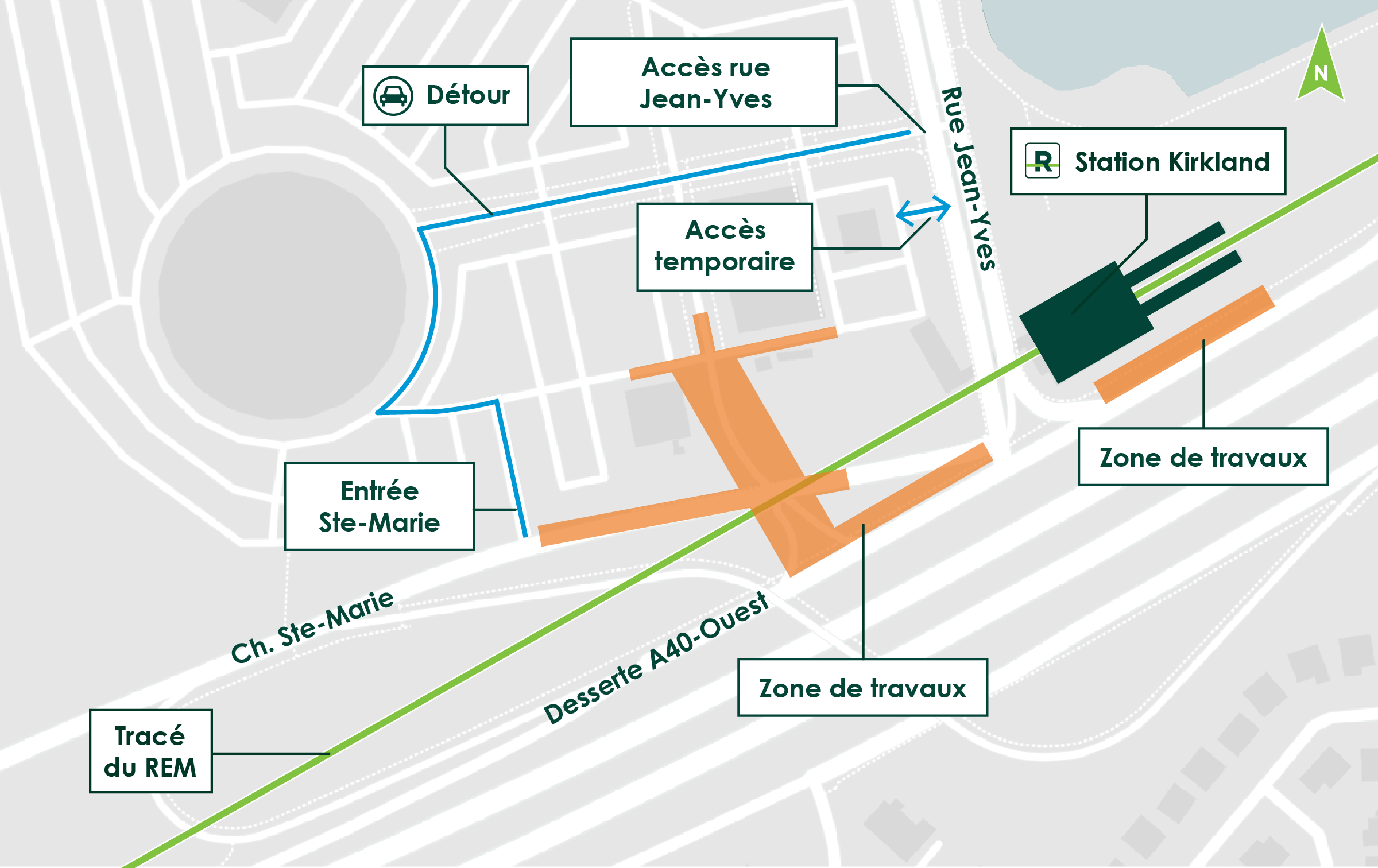
Maintaining the obstruction on Jean-Yves Street between the service road and the RioCan Kirkland Centre
Until April 2023
Nature of Work:
Construction of the Kirkland station foundations began in January 2022 and is well underway. In order to continue and complete certain activities safely, the existing barrier on Jean-Yves Street will have to be extended until April 2023.
Impacts and Mitigation Measures:
- Complete closure of a portion of the streets crossing the RioCan Kirkland Centre, between Ste-Marie Road and Jean-Yves Street. A detour will be implemented via Houde Street. Flagmen and appropriate signage will be in place to facilitate traffic flow around the work site.
- Access to businesses will be maintained during the entire work period.
- Noise may be generated by this work. In order to ensure compliance with the noise criteria to which the project is subject, a follow-up is being conducted by environmental experts.
The map below indicates the work area and available detours:
Obstruction at the RioCan Kirkland Centre
In order to allow for the repair of certain street sections crossing the RioCan Kirkland Centre, an obstruction will be necessary on the street located between Chemin Ste-Marie and the street that is used to access the Centre, from Jean-Yves. This closure will only be in place during the day on November 3, 2022, between approximately 6 am and 5 pm.
Impacts and Mitigation Measures:
- Complete closure of a street crossing the RioCan Kirkland Centre, between Chemin Ste-Marie and the street that is used to access the Centre, from Jean-Yves.
- A detour will be implemented via the parking lot. Flagmen and appropriate signage will be in place to facilitate traffic around the work site.
- Access to businesses will be maintained during the entire work period.
- Noise may be generated by this work. In order to ensure compliance with the noise criteria to which the project is subject, a follow-up is being conducted by environmental experts.
The map below indicates the work area and the detour for motorists.
For all questions | 1 833 REM-INFO
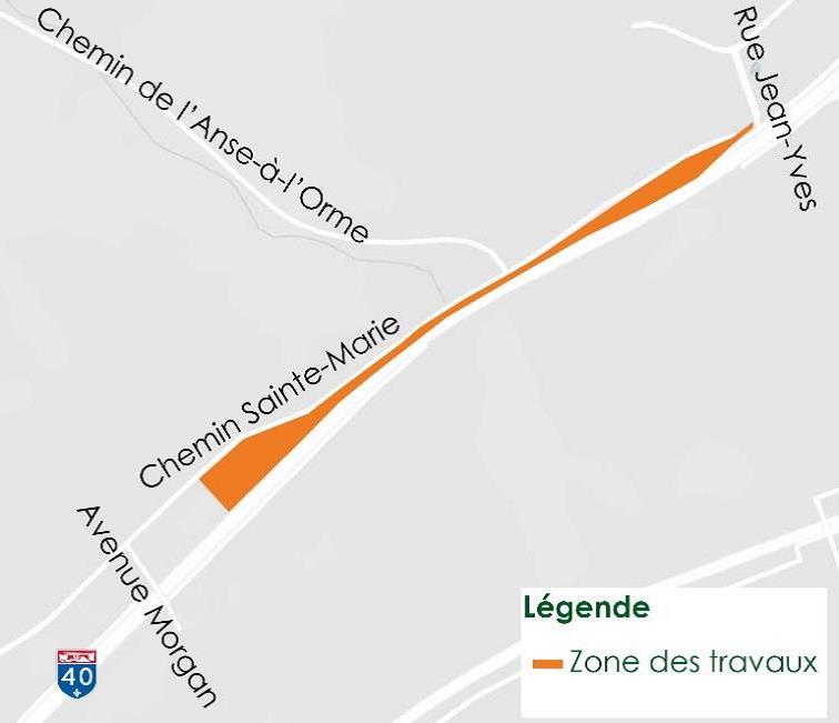
Alternating traffic on Chemin Sainte-Marie, at the intersection of chemin de l’Anse-à-l’Orme
From November 1 to 25, 2022
Work carried out for the REM will require the closure of one lane on Chemin Sainte-Marie at the intersection of chemin de l’Anse-à-l’Orme, from November 1 to 25.
During this period, single lane alternating traffic will be in effect.
Traffic will be controlled by temporary traffic lights.
We thank you for your patience and understanding.
Closure of the Sainte-Marie Overpass
in the westbound direction
Overnight closure from October 14, 11 pm to October 15, 5 am
Due to roadwork required for the REM, the Sainte-Marie overpass will be closed in the westbound direction from October 14 at 11 p.m. to October 15 at 5 a.m.
Motorists are asked to follow the detour route posted on site to bypass the work area.
For more information: 1 833 rem-info, rem.info/en/contact-us
Thank you for your patience and understanding.
Chemin Sainte-Marie:
Temporary night closures on August 18-19 and 21-22
Please note that transportation of electrical infrastructure required by the REM will cause temporary closures on Chemin Sainte-Marie and A40-W service road, according to the following schedule:
- From 11 p.m. on August 18, to 5 a.m. on August 19 : north side of A40
- From 11 p.m. on August 21, to 5 a.m. on August 22: south side of A40
Traffic hindrances are to be expected. Motorists are asked to follow detour routes posted on site.
Thank you for your patience and understanding.
Road closures on Chemin Sainte-Marie
Date: Beginning July 8, 2022, for a month and a half*.Where: Chemin Sainte-Marie between Morgan Boulevard and Chemin de
*These dates are subject to change. |
Nature of the work:
For ongoing work to build the infrastructure for the REM, road blockages will be necessary on a
portion of Chemin Sainte-Marie, between Morgan Boulevard and Chemin de l’Anse-à-l’Orme.
Phase 1 – From Friday, July 8, at 10 p.m., to Monday, July 11, at 5 a.m.: Complete
closure of Chemin Sainte-Marie, in both directions.
The map below shows the work zone:
Phase 2 – Starting July 11, for six weeks: Closure of eastbound lane only.
The map below shows the work zone:
Impacts and mitigation measures:
The goal of the REM project office and the NouvLR consortium is to mitigate the impact on local
residents and ensure everyone’s safety by taking all appropriate measures.
- Flaggers and appropriate signage will be present to indicate the detour route.
- Local traffic maintained at all times for access to businesses and companies.
- The bike path and sidewalk will remain accessible while the work is being done.
---------------------------------------------------------------------------------------------------------------------
REM crossing over Highway 40
Date: From May 13 to 30, 2022
Where: Highway 40, at Henri-Bourassa Boulevard
Nature of the work:
From May 13 to 30, 2022, traffic disruptions are planned on Highway 40 at Henri-Bourassa Boulevard as part of the construction of the REM elevated structure on the West Island. This operation will involve installing the REM deck over Highway 40. This major crossing will be carried out in several phases to complete the tracks in the Technoparc sector leading to the new Marie-Curie station.
Anticipated impacts and mitigation measures:
Sections of Highway 40 and service roads in that sector will be closed, as the REM – Highway 40 crossing progresses.
Complete closure of the following sections:
|
Phase 1 |
Highway 40 westbound service road |
Weekends |
May 13, from10 p.m. to May 16, at 5 a.m. |
|
Phase 2 |
Highway 40 West |
At night*, between 11 p.m. and 5 a.m. |
May 16 to 20 |
|
Phase 3 |
Highway 40 East |
At night*, between 11 p.m. and 5 a.m. |
May 23 to 27 |
|
Phase 4 |
Highway 40 eastbound service road |
Weekends |
May 27, from 10 p.m. to May 27, at 5 a.m. |
*During overnight closures, traffic lanes will remain open during the day.
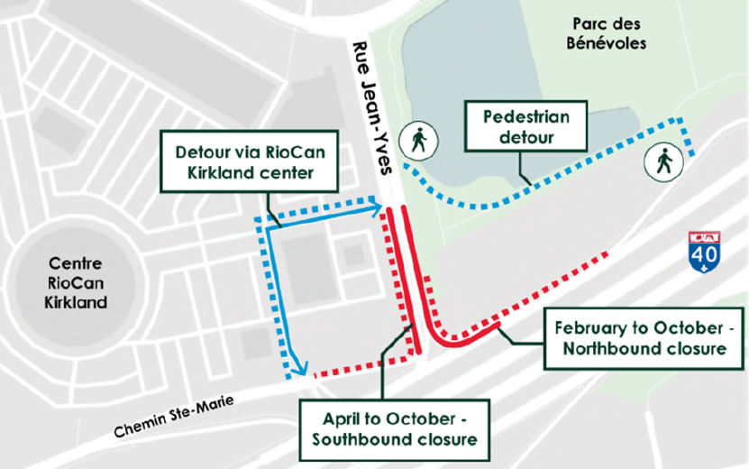
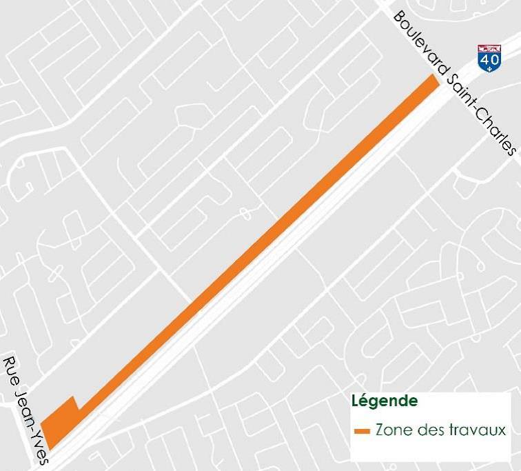
Obstruction on Jean-Yves Street
between the service road and the RioCan Kirkland Centre
Date: From April 5 to October 2022
Where: Jean-Yves Street, between the service road and the shopping centre
Nature of the work:
To continue construction of the station and the future pedestrian walkway, an additional obstruction will be required on southbound Jean-Yves Street. This obstruction will be mobilized starting April 5, in addition to the obstruction already in place on northbound Jean-Yves Street.
Impacts and mitigation measures:
- Complete closure of a portion of Jean-Yves Street and the sidewalks, between the service road and the shopping centre. There will be a detour via the RioCan shopping centre. Flaggers and appropriate signage will be in place to direct traffic around the work site.
- Access to businesses will be maintained for the duration of the obstruction. Pedestrians will be able to walk safely via Bénévoles Park to get around the obstruction.
- This work may generate noise and truck traffic. Environmental experts will monitor noise to ensure project criteria are met.
The map below shows the work zone and the detour for motorists and pedestrians:
Obstructions on Jean-Yves Street, southbound,
between the service road and the RioCan Kirkland Centre
Date: From February 9 to 11, 2022, between 9 a.m. and 3 p.m.*
Where: Jean-Yves Street southbound, between the service road and the shopping center
*Dates subject to change.
Nature of the work:
In order to install the guardrails of the overhead structure that spans Jean-Yves Street, an additional obstruction will be required on Jean-Yves Street southbound.
This obstruction will take place daily from February 9 to 11, 2022, between 9:00 a.m. and 3:00 p.m.; in addition to the obstruction already in place on Jean-Yves Street northbound. The map below shows the work zone and the detour for motorists and pedestrians:
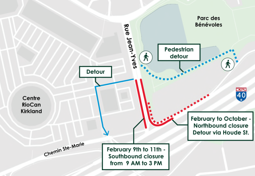
Impacts and mitigation measures:
- Complete closure of a portion of Jean-Yves Street, southbound, between the service road and the shopping centre. There will be a detour via the RioCan shopping center. Flaggers and appropriate signage will be in place to direct traffic around the work site.
- Access to businesses will be maintained for the duration of the obstruction. Pedestrians will be able to walk safely via Bénévoles Park to get around the obstruction.
- This work may generate noise and truck traffic. Environmental experts will monitor noise to ensure project criteria are met.
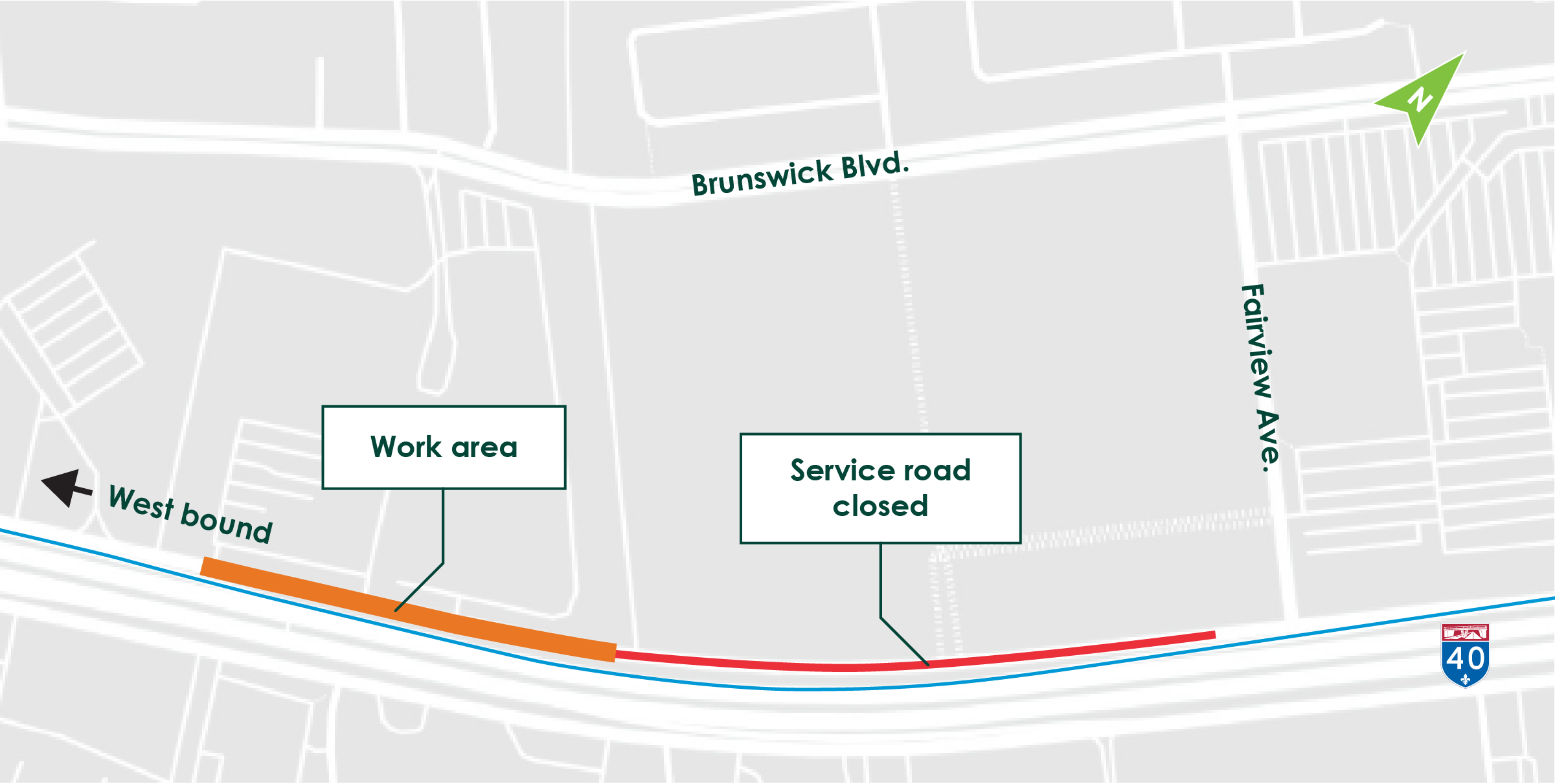
Complete closure of Saint-Charles Boulevard between Brunswick and Hymus Boulevards
From November 29, 10 p.m. to November 30, 5 a.m.
Please note that installation of guard rails for the construction of the REM’s elevated structure will require the complete closure of Saint-Charles Boulevard between Brunswick and Hymus Boulevards, from November 29, 10 p.m. to November 30, 5 a.m.
Traffic hindrances are to be expected. Motorists are asked to follow detour routes posted on site to bypass the work area.
Thank you for your patience and understanding.
Chemin Sainte-Marie (between Ste-Anne-de-Bellevue and Meaney St.):
Traffic disruptions to be expected on Saturday, November 20,
between 10 am and 4 pm
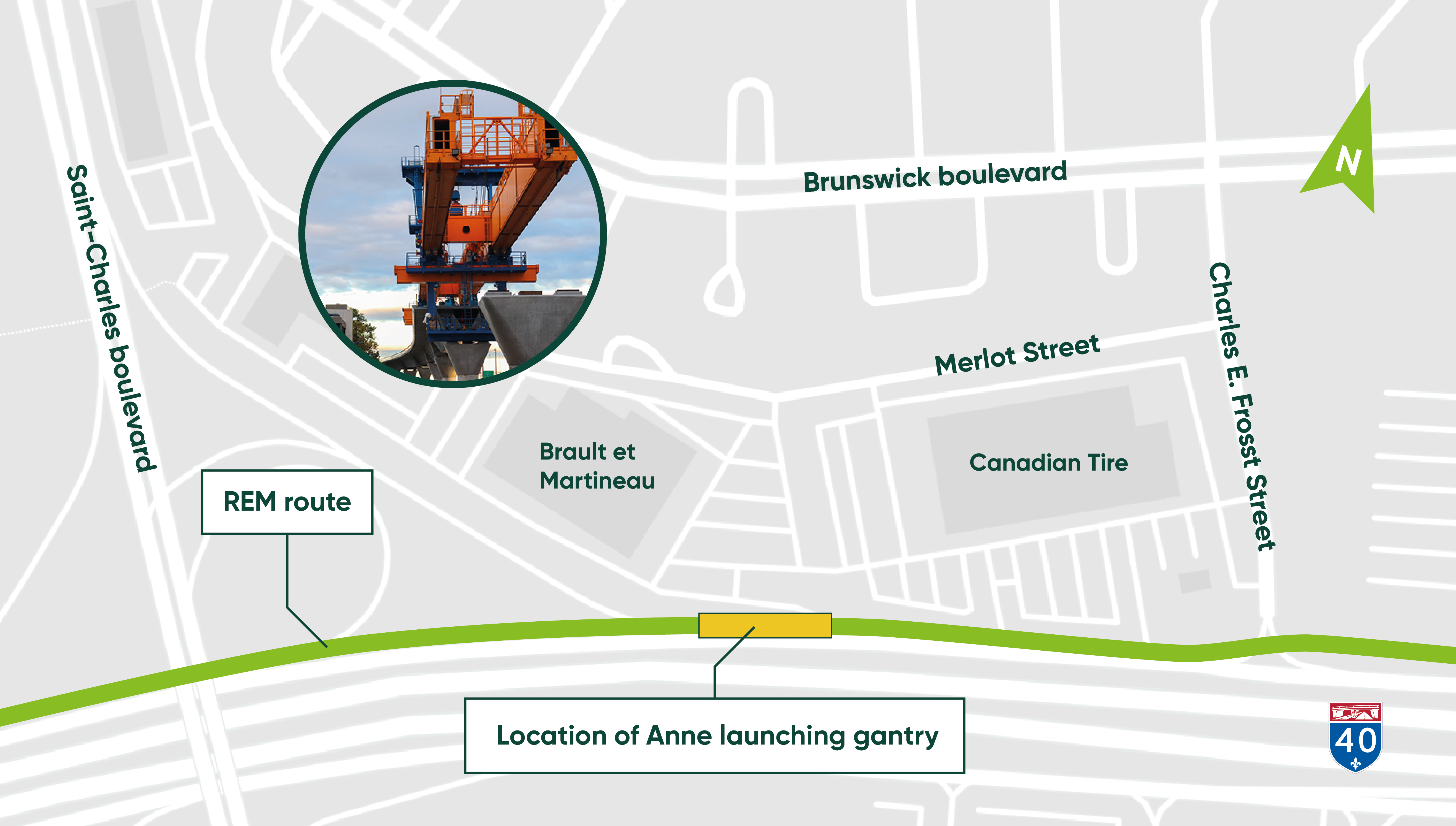
Road closures are to be expected on Chemin Sainte-Marie, Saturday, November 20, twice between the hours of 10 a.m. and 4 p.m. for an approximate duration of 15 minutes each time.
These road closures are required to move eastwards the launching gantries along Chemin Sainte-Marie, to reach highway 40.
A flagman will be on site to direct traffic.
Complete closure of Charles-E. Frosst Street
Dates: November 8 to November 12, 2021
Times: from 9 a.m. to 3 p.m.
Motorists are asked to follow the detour route posted on site to bypass the work area.
Construction of the elevated structure
Day and night work
Date: Late August to late September 2021*
Weekdays and weekends, day and night
Where: Timberlea area, Kirkland
Nature of the work:
Construction of the elevated structure is continuing in the West Island.
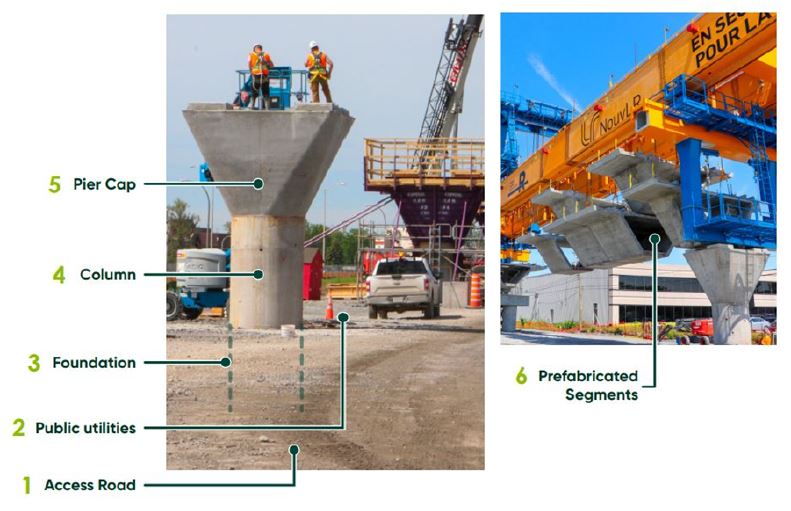
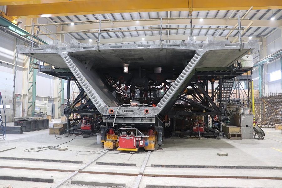
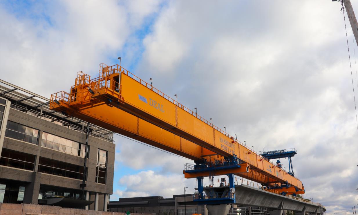
The installation of the elevated structure’s deck is continuing with the help of launching gantry “Anne,” which lifts and assembles the prefabricated segments (number 6 on the image below) to form the deck on which the REM will travel. Earlier this year, work resumed using the launching gantry west of Fairview station. This work will be completed at Anse-à-l’Orme station by the end of the year.
Most of the noise caused by this work comes from the alarm that is triggered when the gantry is raised and lowered, as a safety measure, to warn workers and anyone else in the vicinity. The rapid progress of the segment assembly limits how long the launching gantry will be in your area.
Each pillar you see along Highway 40 consists of a foundation (number 3 in the image below), a column (number 4 in the image below), and a pierhead (number 5 in the image below). The space between each pillar is called a span. There are 12 segments per span and it takes, on average, two days to put up a span and form the deck.
Impacts and mitigation measures:
- Night work will take place during this period.
- This work will generate noise. Experts will monitor the work and mitigation measures may be put in place if necessary.
- There will be lighting on site. A special effort will be made not to point the lights toward neighbouring homes.
Closed Access: Chemin Sainte-Marie Westbound
Dates: August 9 to 11, 2021 from 10 p.m. to 5 a.m.
Please note that access to Chemin Sainte-Marie on the westbound service road of A-40 will be closed from August 9 to 11, 2021 from 10 p.m. to 5 a.m. to install the prefabricated segments (cement sections) for the REM.
Motorists are asked to follow the detour route posted on site to bypass the work area.
Update: August 24, 2021
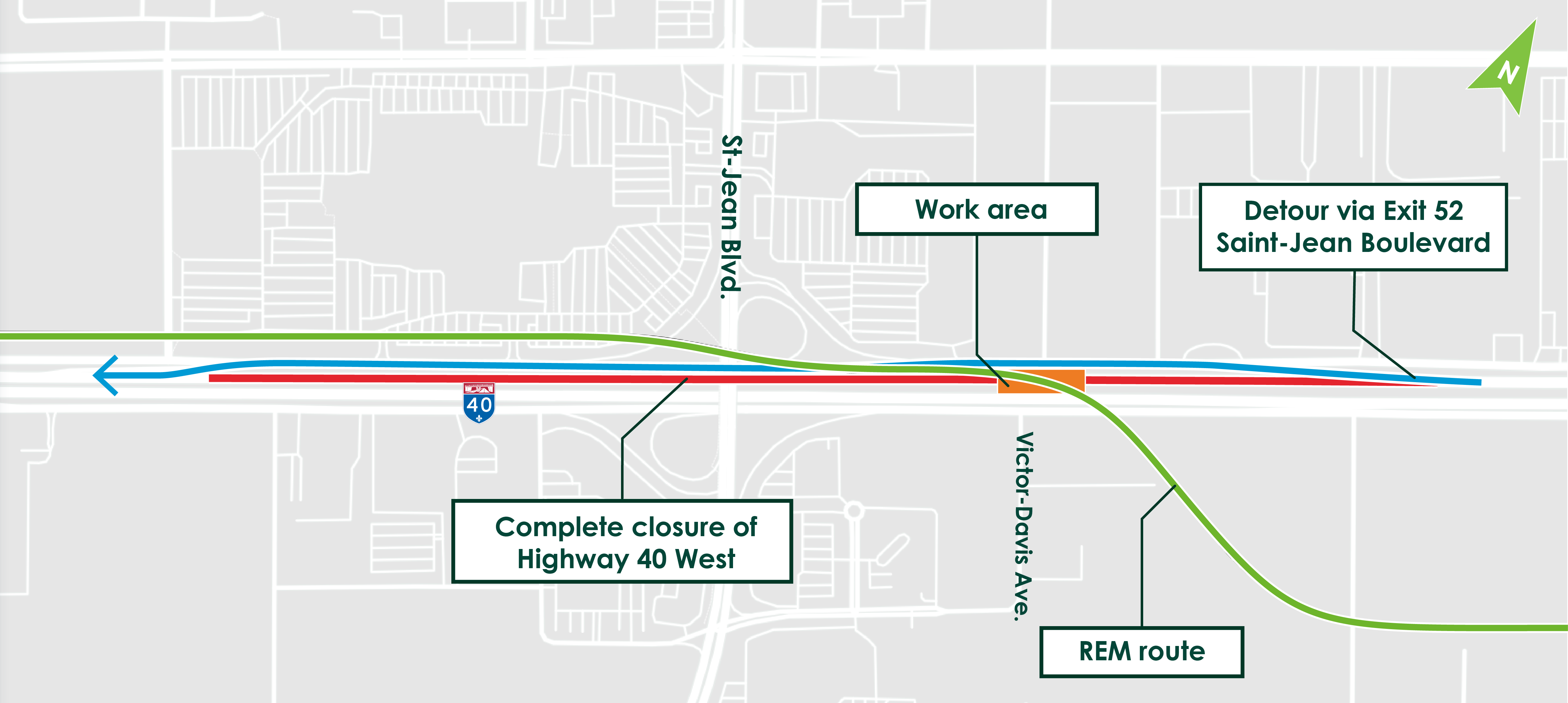
REM crossing over A40
Date : August 2, to September 10, 2021*
Schedule: Nighst and weekends
Where: Highway 40, at Saint-Jean Boulevard
Nature of the work:
Beginning August 2, traffic pattern disruptions are planned on Highway 40 (A40) at Saint-Jean Boulevard within the framework of REM elevated structure construction on the West Island. These operations will allow the REM deck over A40 to be installed. This “major crossing” will be carried out in several phases over a period of approximately one month (from August 2 to September 10).
Anticipated impacts and mitigation measures:
Sections of the A40 and service roads in that sector will be closed, as the REM – A40 crossing progresses.
Complete closure of the following sections
|
Phase 1 |
A40 eastbound service road |
At night*, between 10 p.m. and 5 a.m |
August 2, 10 p.m. to August 6, 5 a.m |
|
Phase 2 |
A40 East |
Weekends |
August 6, 11 p.m. to August 9, 5 a.m |
|
Phase 3 |
A40 West |
At night*, between 11 p.m. and 5 a.m |
August 9, 11 p.m. to August 13, 5 a.m |
|
Phase 4 |
A40 West |
Weekends |
August 13, 11 p.m. to August 16, 5 a.m |
|
At night*, between 11 p.m. and 5 a.m |
August 16, 11 p.m. to August 17, 5 a.m |
||
|
Phase 5 |
A40 West service road |
At night*, between 10 p.m. and 5 a.m |
August 25, 10 p.m. to Sept. 1, 5 a.m. |
|
Phase 6 |
A40 West service road |
At night*, between 10 p.m. and 5 a.m |
To be determined |
*During overnight closures, traffic lanes remain open during the day
Phase 1 – August 2 to 6, 2021*: overnight closure of eastbound service road
– 10 p.m. to 5 a.m.: complete closure of the eastbound service road at Saint-Jean Boulevard.
Detour
– Detour via Hymus Boulevard to Doyon Avenue and then back to the A40 eastbound service road.
– The A40 will remain open to traffic during this period.
Phase 2 – August 6 to 9, 2021*: weekend closure of Highway 40 eastbound
– From August 6, 11 p.m. to August 9, 5 a.m., complete closure of Highway 40 eastbound at Saint-Jean Boulevard.
Detour
– Detour to Highway 20 via Saint-Charles Boulevard to Des Sources Boulevard and then back to the A40 eastbound.
– The A40 westbound will remain open to traffic during this period.
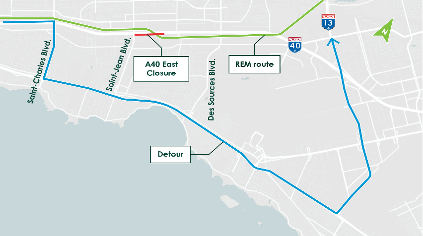
Phase 3 – August 9 to 13, 2021*: overnight closure of Highway 40 westbound
– 11 p.m. to 5 a.m., complete closure of Highway 40 westbound at Saint-Jean Boulevard.
Detour
– Detour to Highway 20 via Highway 13 to Saint-Charles Boulevard and then back to the A40 westbound.
– The A40 eastbound will remain open to traffic during this period.
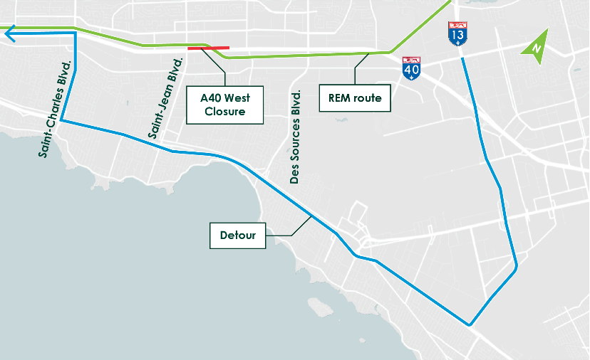
Phase 4A – August 13 to 16, 2021*: weekend closure of Highway 40 westbound
– From August 13, 11 p.m. to August 16, 5 a.m., complete closure of Highway 40 westbound at Saint-Jean Boulevard.
Detour
– Detour to Highway 20 via Highway 13 to Saint-Charles Boulevard and then back to the A40 westbound.
– The A40 eastbound will remain open to traffic during this period.

Phase 4B – August 16 to 17, 2021*: overnight closure of Highway 40 westbound
– From August 16, 11 p.m. to August 17, 5 a.m., complete closure of Highway 40 westbound at Saint-Jean Boulevard.
Detour
– Detour to Highway 20 via Highway 13 to Saint-Charles Boulevard and then back to the A40 westbound.
– The A40 eastbound will remain open to traffic during this period.
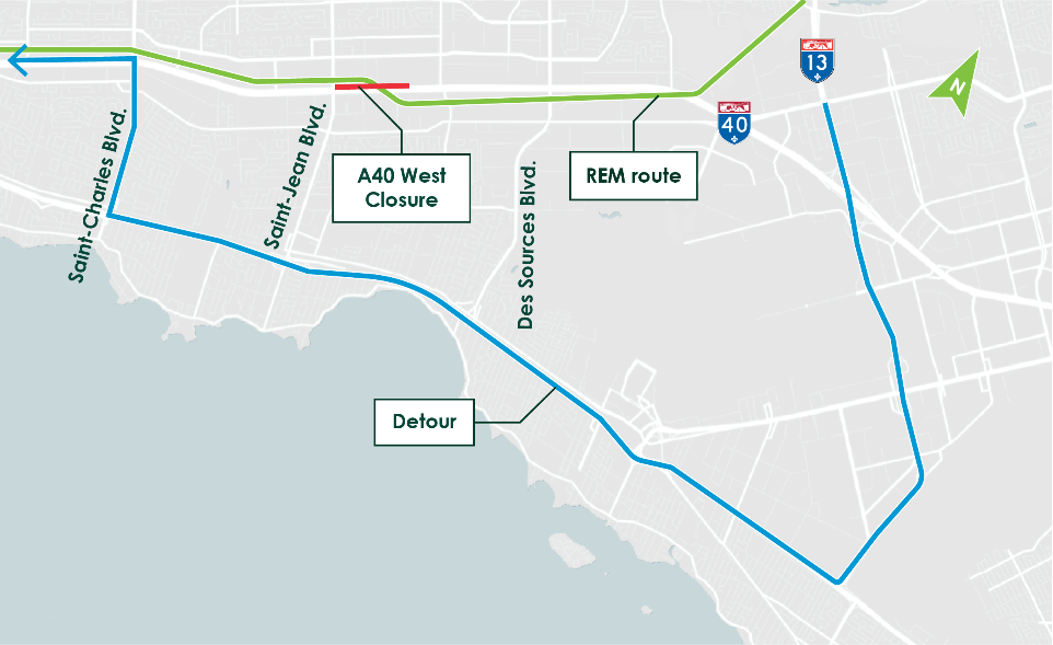
Phase 5 – August 25, 10 p.m. to Sept. 1, 5 a.m.
– 10 p.m. to 5 a.m.: complete closure of the Highway 40 westbound service road at Saint-Jean Boulevard.
Detour
– Detour via Brunswick Boulevard to Saint-Jean Boulevard and then back to the A40 westbound service road.
– The A40 will remain open to traffic during this period.
Phase 6 – to be determined*: overnight closure of the westbound service road
– 10 p.m. to 5 a.m.: complete closure of the Highway 40 westbound service road at Saint-Jean Boulevard.
Detour
– Detour via Brunswick Boulevard to Saint-Jean Boulevard and then back to the A40 westbound service road.
– The A40 will remain open to traffic during this period.
* Scheduled dates are subject to change according to work progress and weather conditions.
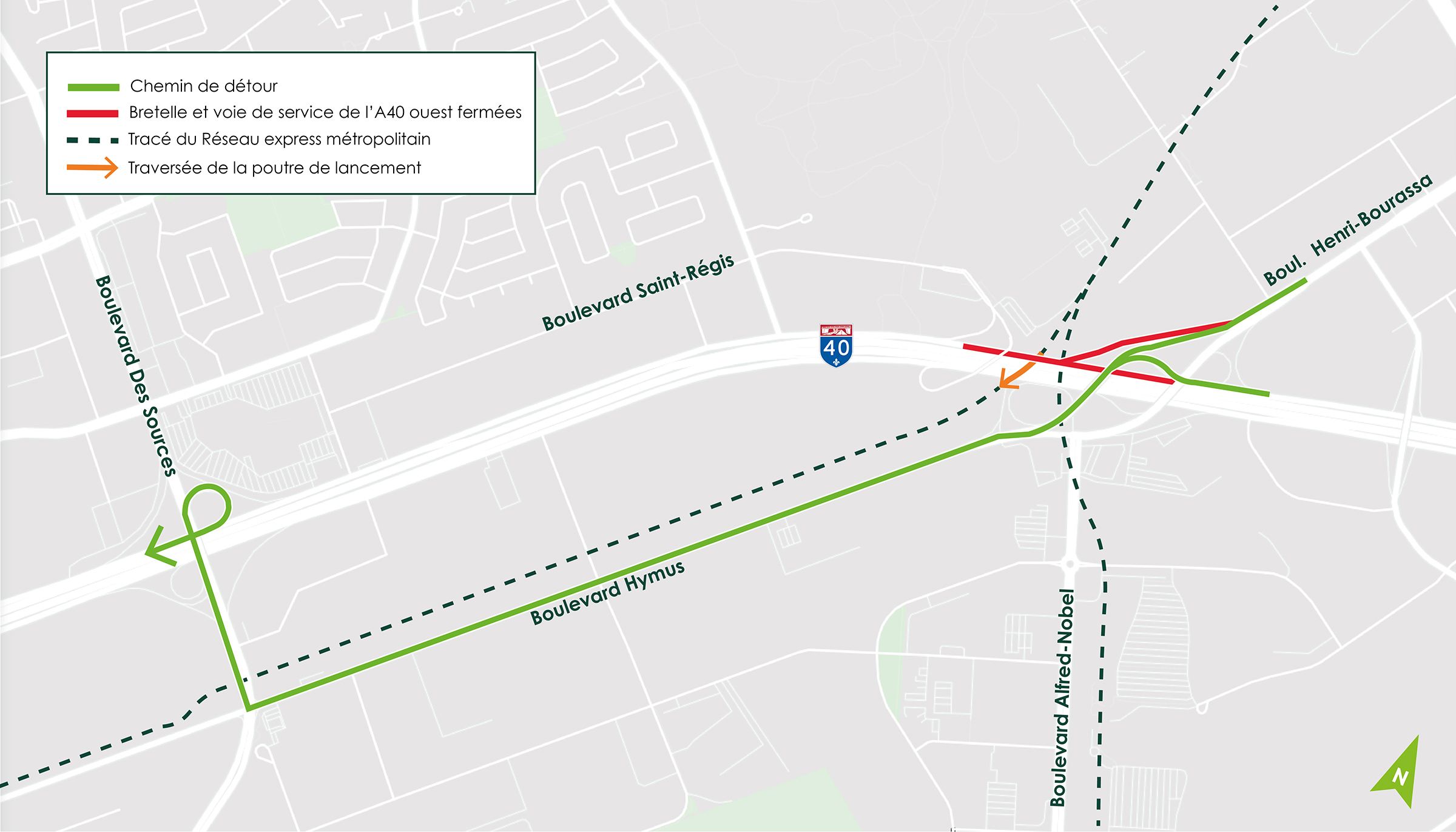
Crossing of the launching gantry above Chemin Ste-Marie and Jean-Yves Street
Date:* Starting June 27, 2021, for about two months
Where: Chemin Sainte-Marie, at the intersection of Jean-Yves Street
Nature of the work:
As part of construction of the REM’s elevated structure of the REM at the level of Kirkland station, Jean-Yves Street and Chemin Sainte-Marie will be closed to traffic in order to install the segments using the launching gantry. This crossing will include three consecutive phases blocking Jean-Yves Street and Chemin Ste-Marie. A detour will be set up for each of the obstructions and access to businesses and homes will be maintained at all times.
The map below the right shows the location of the various phases.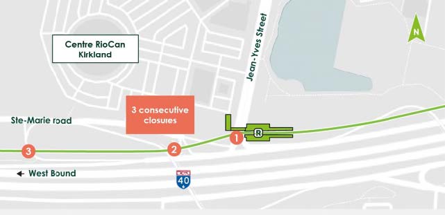
The map below illustrates the 2nd phase of traffic disruptions.
Complete closure of the marked zone:
Date: July 12 to 16, 2021 from 10 p.m. to 5 a.m.
Where: Eastbound Overpass on chemain Sainte-Marie
The Eastbound overpass on chemin Sainte-Marie will be closed to traffic from July 12 to 16, in order to raise the prefabricated segments (cement sections). A detour will be set up for motorists.
Impacts and mitigation measures:
-
Lane closures. Flaggers and appropriate signage will be in place to facilitate traffic around the work site.
-
Access to businesses and homes will be maintained during the work.
- This work may generate noise, dust and truck traffic. Environmental specialists will monitor the project to ensure that it complies with applicable noise and air quality criteria. Mitigation measures may be added as required to complement those already in place.
Relocation of utilities in the service road of Highway 40 West, Kirkland
May 10th to mid-July 2021, days and nights
Nature of work:
From May 10th, relocation of sanitary sewer, storm and water mains will be performed in the service road of Highway 40 westbound, between Fairview Avenue and Exit 50.
Impacts and mitigation measures:
A complete closure of the service road is planned for a period of approximately 2 months. Appropriate signage will be installed indicating the proposed detour routes to the West Side Highway service road.
Highway 40 West:
- From Highway 40 West, take exit 50.
Brunswick Boulevard:
- From Fairview Avenue, left turn onto Brunswick Boulevard, then left onto Charles E. Frosst Street to merge onto the Highway 40 West service road.
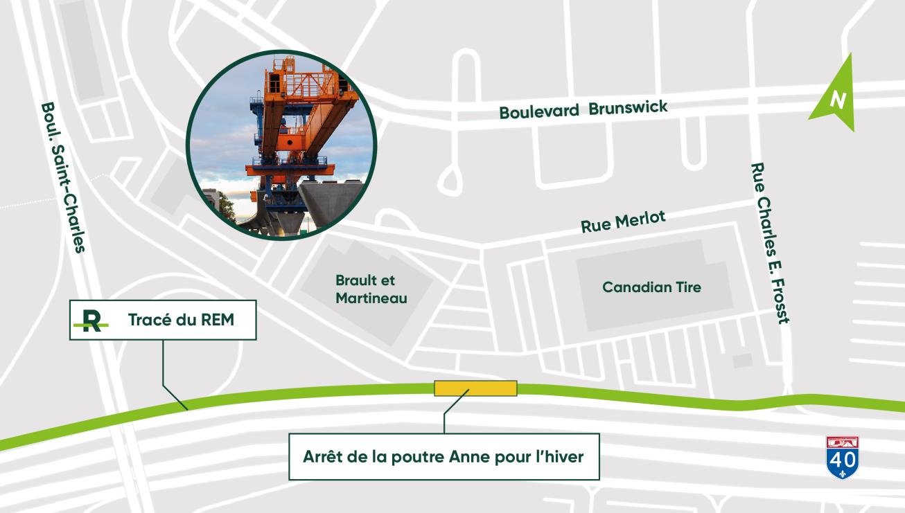
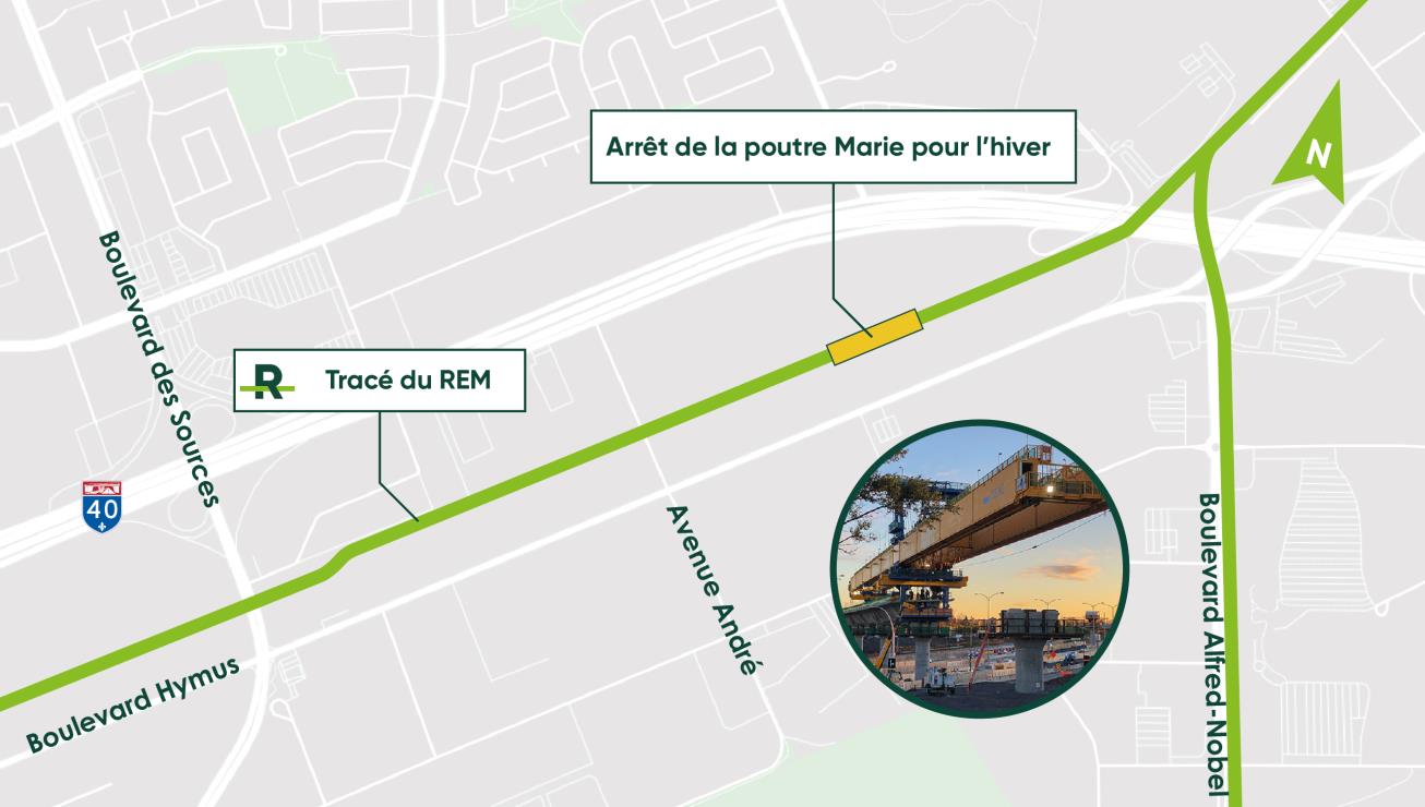
Halt of the launching gantries during winter
Like last year, due to cold weather, the two launching gantries “Anne” and “Marie” stop all winter. They will be secured and their location during this time won’t cause any road traffic. The assembly of prefabricated segments will resume in spring 2020, around April.
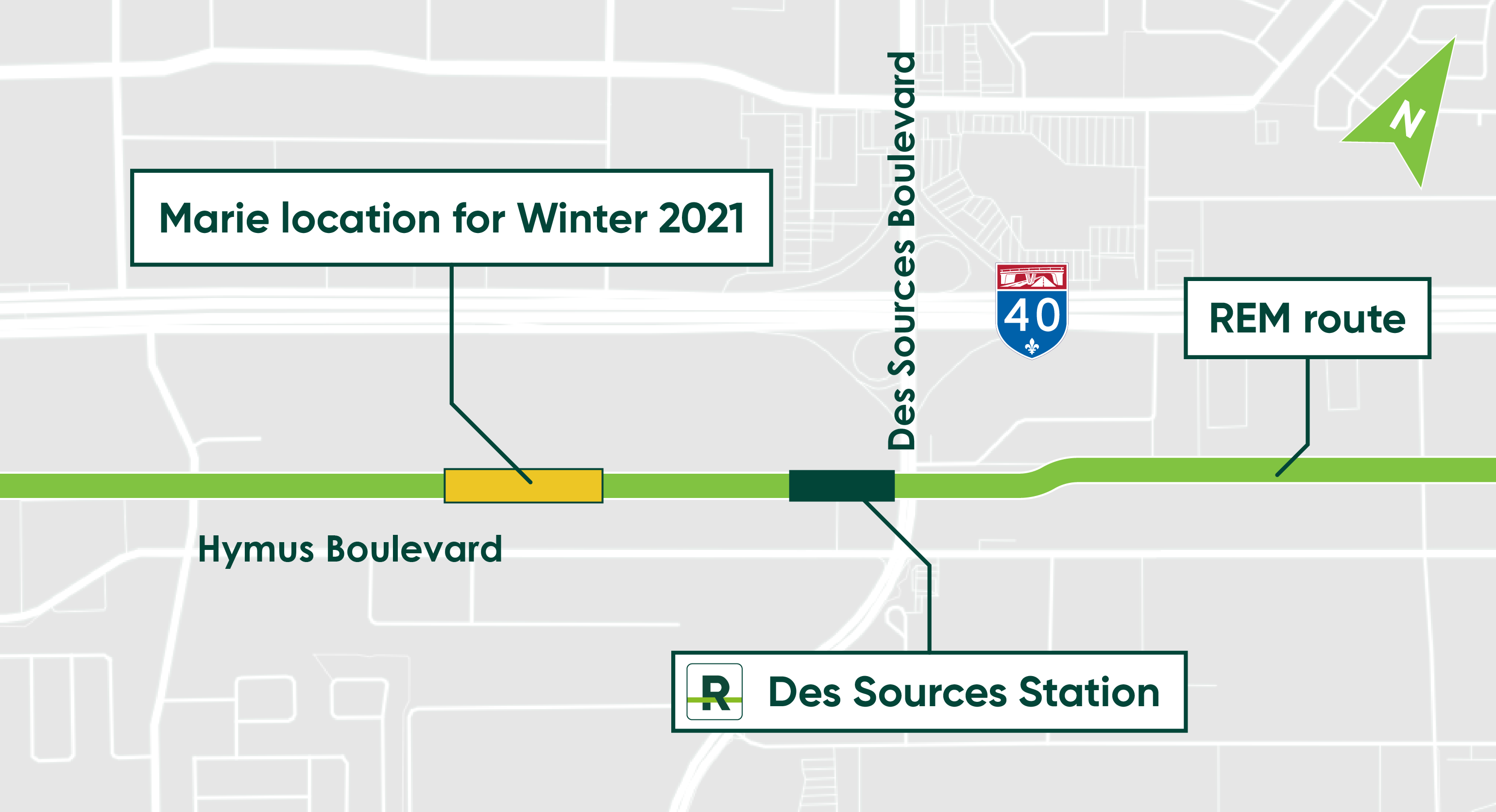
Anne takes a break east of RioCan Center:
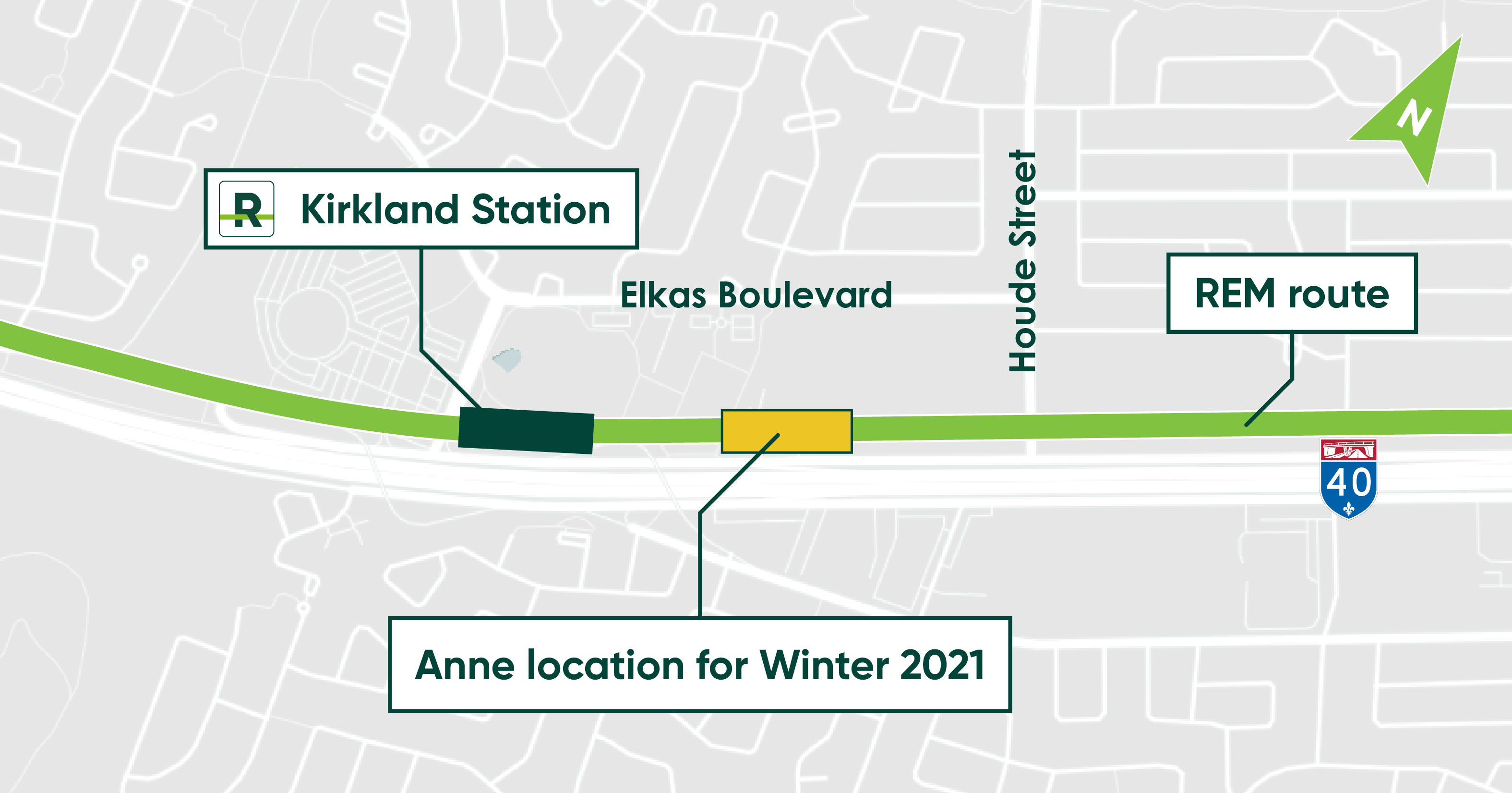
Marie takes a break west of Des Sources Boulevard:
Update: November 11, 2020
Update on the Réseau express métropolitain project:
important report on work completed under exceptional circumstances
-
COVID-19-related impact on the time schedule
-
Modernization of the Mont-Royal Tunnel: two separate safety-related situations that require additionnal work
Montréal, November 11, 2020 - Media representatives were invited today for an update on the Réseau express métropolitain project. CDPQ Infra and the REM project office went over the work completed in 2020 and presented the revised schedule that takes into account the impact of COVID-19 and of two major issues identified in the Mont-Royal tunnel as part of its modernization.
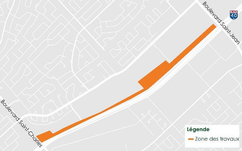
Installation of a gantry for the overhead structure over Highway 40 West, Pointe-Claire
Work to install a gantry, a portion of the elevated structure supported by two pillars, requires the closure of Highway 40 West, near Saint-Jean Boulevard, on weekends only, during the day and at night, in September and October.
A detour will be available via the Highway 40 West service road, by taking the Saint-Jean Boulevard exit (exit 52).
The work schedule is as follows:
|
Planned schedule |
Work |
|---|---|
|
10 p.m. on September 18 to 5 a.m. on September 21 |
Phase 1: Mobilization of the site and lifting of the gantry |
|
10 p.m. on September 25 to noon on September 26 |
Phase 2: Concreting of the structure |
|
10 p.m. on October 30 to 5 a.m. on November 2 |
Phase 3: Dismantling of the gantry and demobilization of the site |
|
November 5, 11 p.m. to 5 a.m. November 6, 11 p.m. to 10 a.m. |
Finishing work |
The map below illustrates where traffic disruptions will occur as well as the detour route during the complete closure
Impacts and mitigation measures
As with any construction site, the work will generate impacts such as noise, vibration, dust, heavy truck traffic and traffic disruptions. Mitigation measures will be implemented to minimize these impacts. The REM project office and the NouvLR consortium will endeavour to prevent or minimize the impact on surrounding residents as much as possible and ensure safety by implementing all appropriate measures.
Update: September 4, 2020
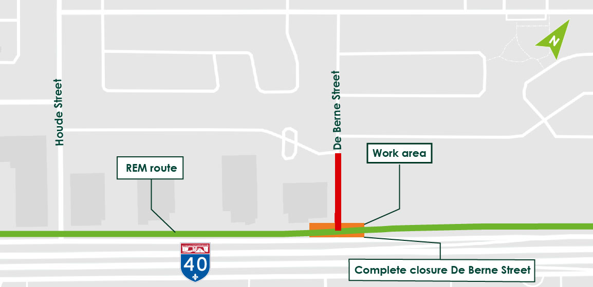
REM crossing over De Berne Street
September 7 to 9, day and night
Nature of work
As part of the construction of the REM’s elevated structure on the West Island, De Berne Street will be closed completely from September 7-9 to finish construction of the elevated structure deck by installing the prefabricated segments.
The work schedule is as follows*:
- September 7, 7 p.m. to September 8, 3 p.m.
Complete closure of De Berne Street, in both directions, from Vincent-Blouin to the service road. Traffic will be detoured via Houde Street.
- September 8, 7 p.m. to September 9, 3 p.m.
Complete closure of De Berne Street, in both directions, from Vincent-Blouin to the service road. Traffic will be detoured via Houde Street.
Impacts and mitigation measures
As with any construction site, the work will generate impacts such as noise, vibration, dust, heavy truck traffic and traffic disruptions. Mitigation measures will be implemented to minimize these impacts. The REM project office and the NouvLR consortium will endeavour to prevent or minimize the impact on surrounding residents as much as possible and ensure safety by implementing all appropriate measures.
Update: August 28, 2020
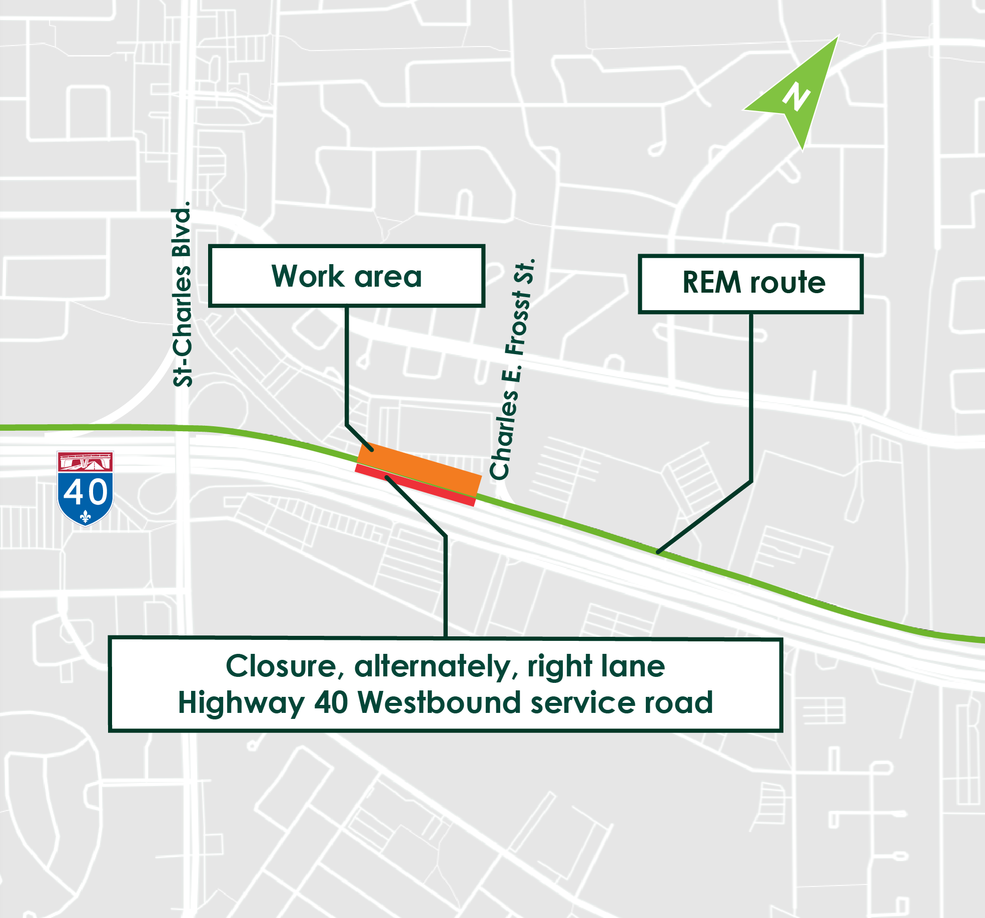
Water main re-routing work, Highway 40 West service road, Kirkland
September 3 to October 26, day and night
Nature of work
The work consists of re-routing a water main.
Complete closure of the right lane on the Highway 40 West service road between Charles E. Frosst Street and the Saint-Charles Boulevard access ramp will be required for this portion of the work.
The work schedule is as follows:
|
|
|
|---|---|
|
September 3, 4, 5, at night |
|
|
September 7 to September 28*, day and night |
|
|
September 28, overnight |
|
|
September 29 to October 26*, day and night |
|
|
October 26 and 27, overnight |
|
The map below shows the work zone
Update: August 7, 2020
Complete closure of Highway 40 West service road
July 31 to August 3, August 7 and 8, August 21 to 24, day and night
Nature of the work
The Highway 40 West service road will be closed near Saint-Jean Boulevard for three consecutive weekends because of gantry installation work.
A gantry, a portion of the elevated structure supported by two pillars, will be installed to help support loads. The gantry will be installed on either side of the Highway 40 West service road in anticipation of further construction of the elevated structure.
Detour options
A detour will be possible via Tecumseh and Selkirk Avenues and Brunswick Boulevard.
Another detour route will be possible via Saint-Jean Boulevard, Labrosse Avenue, Selkirk Avenue and Brunswick Boulevard.
An optional route will also be accessible via Highway 40 westbound.
The work schedule is as follows*
|
Scheduled obstructions |
Work |
|---|---|
|
July 31 at 10 p.m. to August 3 at 5 a.m. |
Phase 1 |
|
August 7 at 10 p.m. to August 8 at noon |
Phase 2 |
|
August 21 at 10 p.m. to August 24 at 5 a.m. |
Phase 3 |
*The current sequence and dates are subject to change without notice.
The map below illustrates where traffic disruptions will occur as well as the detour routes during the complete closure of the Highway 40 West service road:
REM crossing over Saint-Charles Boulevard
Last update: June 23, 2020
Road obstructions are planned on and near Saint-Charles Boulevard as part of the construction of the REM’s elevated structure on the West Island. This operation will involve installing the segments that will form the REM’s deck over Saint-Charles Boulevard.
The work will be carried out at night only. During the day, traffic will remain open on all lanes and vehicles will be able to travel safely under the structure.
Here are the three phases of traffic obstructions**
Phase 1
June 7 to 11, 11 p.m. to 5 a.m.
Complete closure of the service road ramp from Highway 40 West to Saint-Charles Boulevard North. Signs will specify the detour to be taken.
Phase 2
June 25 to June 29, 10 p.m. to 6 a.m.
Complete closure of Saint-Charles Boulevard in both directions. Signs will specify the detour to be taken.
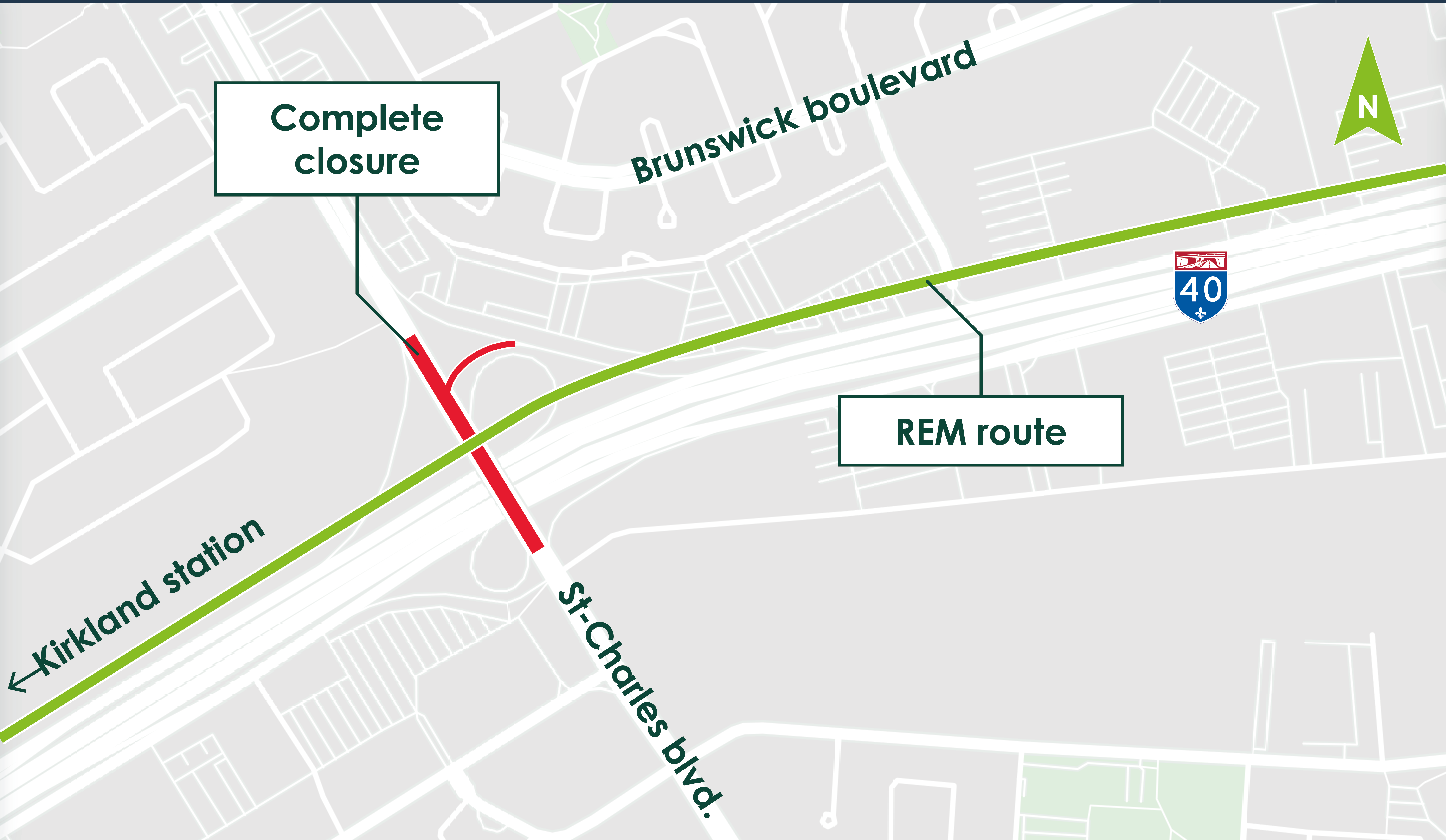
Phase 3
July 8 to 10, 10 p.m. to 6 a.m.
Complete closure of the service road ramp from Highway 40 West to Saint-Charles Boulevard North. Signs will specify the detour to be taken.
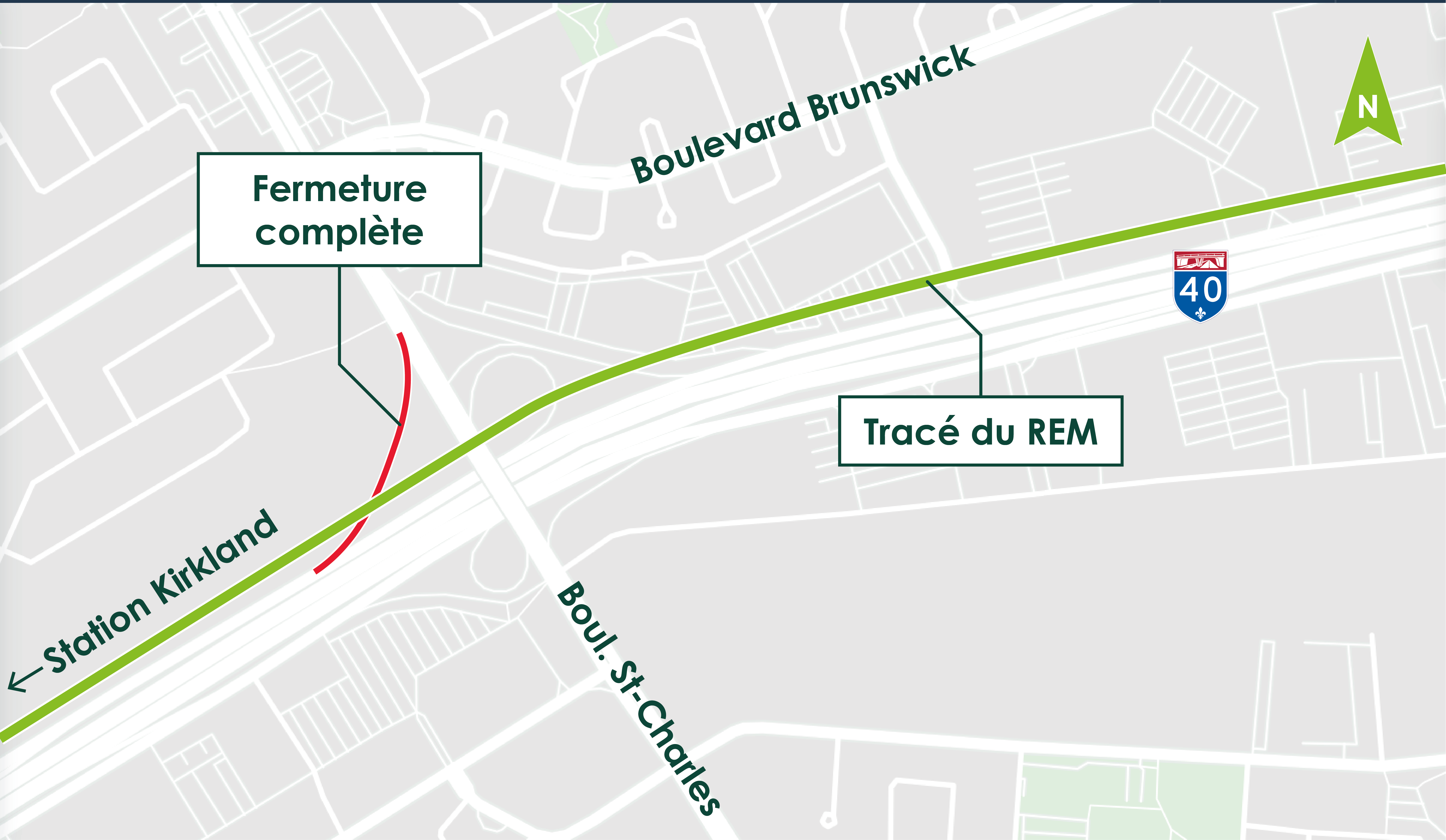
Anticipated impacts and mitigation measures:
Just as for any construction site, the work will generate noise, vibrations, dust, heavy truck traffic and traffic disruptions. Mitigation measures will be implemented to minimize the impacts. The REM project office and NouvLR consortium’s goal is to prevent or minimize impact on surrounding residents as much as possible and ensure safety by implementing all appropriate measures
*Work will take place mainly from 11 p.m. to 5 a.m. Work before and after this time period will be necessary to mobilize and demobilize all elements required to carry out the work and to clean up the site. However, due to the nature of the activities being performed, work cannot be interrupted while it is in progress; it must be completed so as to maintain the integrity of the existing infrastructure. Should this situation arise, the work period will be extended to complete the work already begun.
** The current sequence and set dates are subject to change without notice.
Restoration of service for "Marie" and "Anne" launching gantries
Launching gantry work will resume in June, in the Dorval and Kirkland sectors. Assembly of the elevated structure’s deck using prefabricated segments will continue to the end of the year.
Anne will continue east from the Saint-Charles Boulevard ramp:
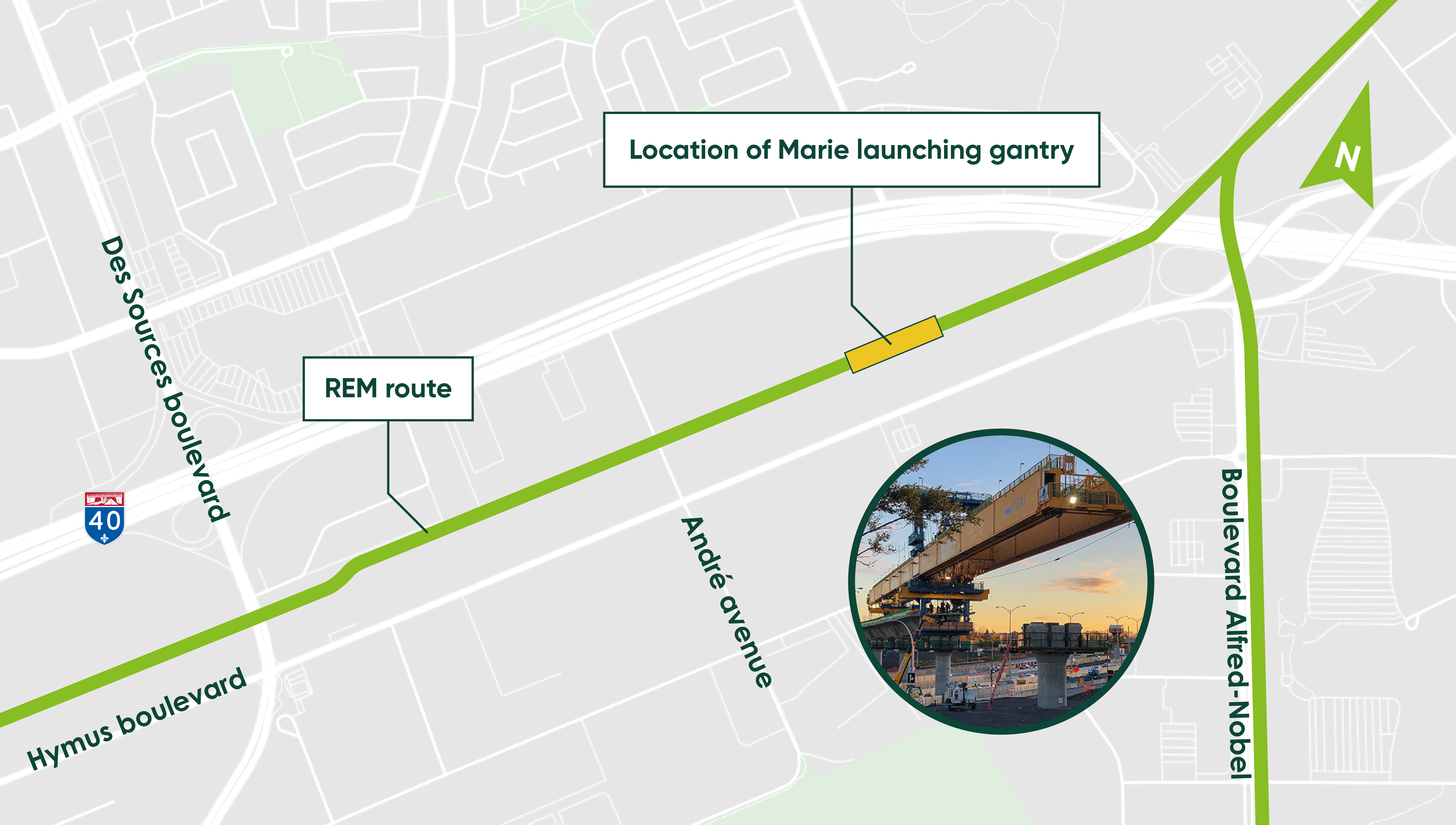
Marie will continue eastward from André Avenue:
Complete night closure of Highway 40,
near Saint-Jean Boulevard (exit 52), Pointe-Claire
Nature of the work:
Construction work on the elevated structure along the median of Highway 40 in the Pointe-Claire sector, near Saint-Jean Boulevard.
To continue this work, complete nighttime closures of Highway 40 East and West are planned in order to reroute the lanes, repaint lane markings and enable the delivery of materials (reinforcing cages).
Highway closures will be done in three stages
Stage 1
Complete closure of Highway 40 East
- May 22, 11 p.m. to 5 a.m.
- May 23, 12 a.m. to 7 a.m.
- The detour will be via the Highway 40 East service road. Signs will indicate the road work and the detour that has been set up.
Stage 2
Complete closure of Highway 40 West
- May 24, 11 p.m. to 5 a.m.
- May 25, 11 p.m. to 5 a.m.
- The detour will be via the Highway 40 West service road. Signs will indicate the road work and the detour that has been set up.
Stage 3
Complete closure of Highway 40 East and West
- May 29, 11 p.m. to 5 a.m.
- June 1, 11 p.m. to 5 a.m.
- The detour will be via the Highway 40 East and West service roads. Signs will indicate the road work and the detours that have been set up.
*The current sequence and dates are subject to change without notice.
Anticipated impacts and mitigation measures:
Just as for any construction site, the work will generate noise, vibrations, dust, heavy truck traffic and traffic disruptions. Mitigation measures will be implemented to minimize the impacts. The REM project office and NouvLR consortium’s goal is to prevent or minimize impact on surrounding residents as much as possible and ensure safety by implementing all appropriate measures.
COVID-19: Construction activities to resume on May 11
Update | April 29, 2020
Following the Québec government’s most recent directives, the Réseau express métropolitain (REM) construction sites will resume activities as of May 11. All measures to ensure workers’ health and safety will be implemented and rigorously enforced. The REM, NouvLR and GPMM management teams will systematically and regularly monitor the situation with the relevant authorities.
With this lifting of the government directives that had suspended all construction site activities, it will be possible to resume the work planned to ensure the modernization of the Deux-Montagnes line and the Mont-Royal Tunnel.
The work will require the complete closure of the section of the Deux Montagnes line between Du Ruisseau station and Central Station as of May 11 and will be carried out in coordination with Mobility Montréal for the implementation of mitigation measures.
Prepatory work near the future Des Sources station
Nature of the work
As part of the work for building the Réseau express métropolitain (REM), preparatory work consisting of tree cutting will be carried out to make way for the future Des Sources station located in Pointe-Claire.
The map below shows the area where tree cutting will take place:
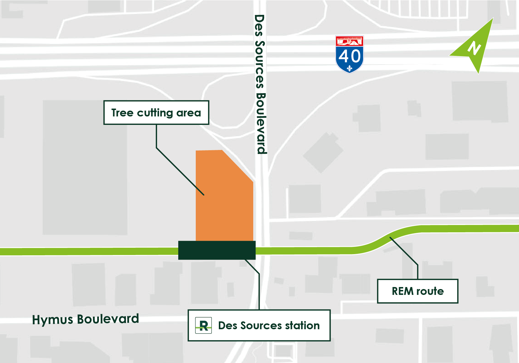
Mitigation measures
- The work will be carried out outside the nesting period (March 31 to August 15) to limit impacts on birds, their nests and eggs.
- These activities will be overseen by environmental experts.
- At-risk plant species and trees will be relocated as required.
- Through a reforestation program, the same number of trees that were cut in temporary construction zones will be replanted, and an additional 10% will be planted in the municipal territory or borough where the trees were cut to make way for the project.
- In addition, a total of 250,000 trees will be planted to offset the GHG emissions produced during the construction phase.
Tour of the segment plant in Saint-Eugène-de-Grantham
It's in Saint-Eugène-de-Grantham, near Drummondville, that the “segments,” i.e. the pieces of concrete used for the REM’s elevated structure, are manufactured.
More than 200 employees of Béton préfabriqué du Lac (BDPL) are hard at work producing 4,550 segments, the equivalent to 14.5 km of elevated structure! This is technical and meticulous work since each segment is custom-made according to the needs of the construction site.
Prefabrication in a local plant allows us to move quickly and guarantee quality, as the segments are manufactured in a controlled environment. We also benefit from the know-how of experienced workers at the plant, which has been involved in other major projects such as the new Champlain Bridge and the Turcot Interchange.
Here is a step-by-step visual presentation or how a segment is manufactured.
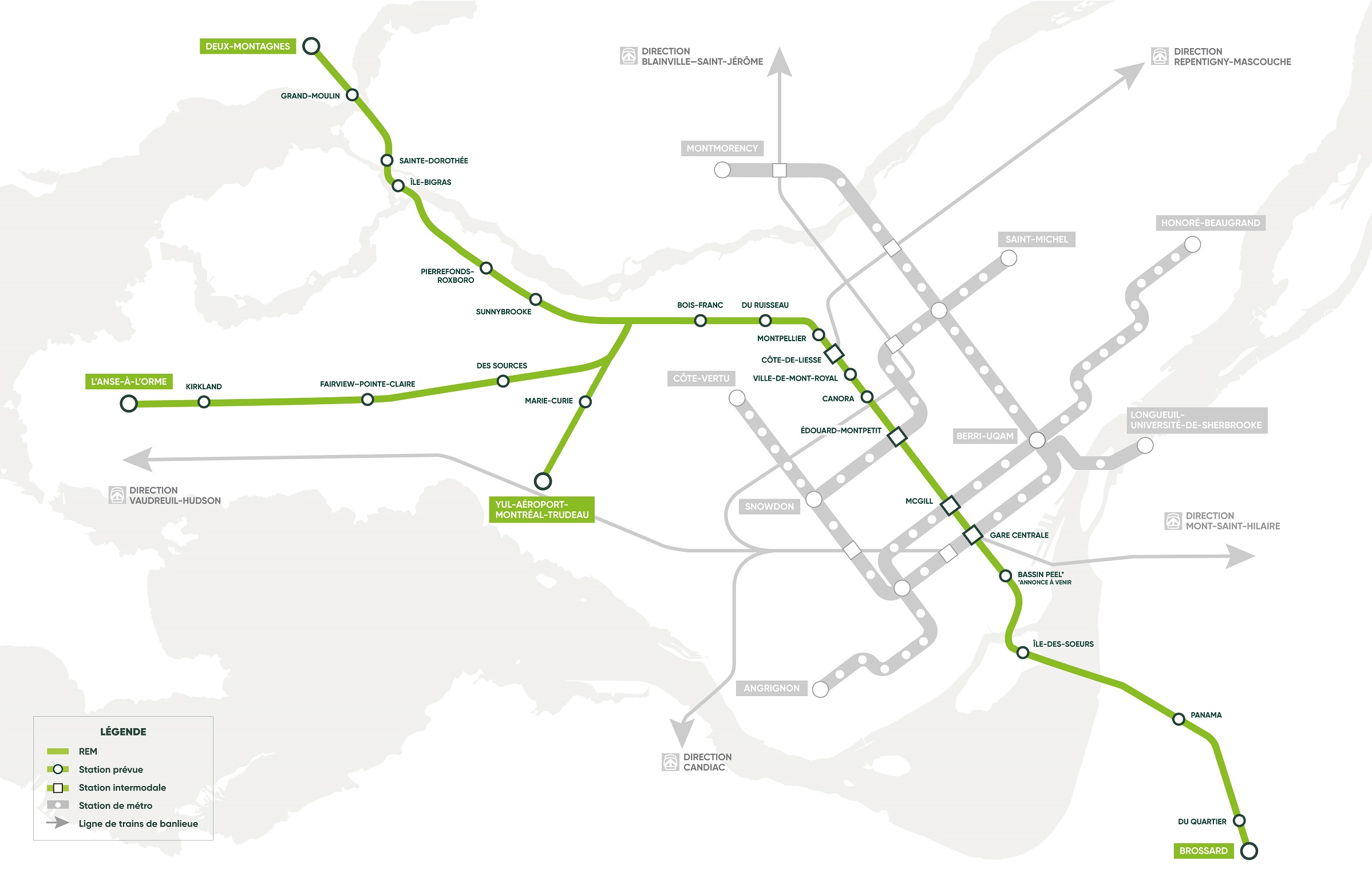
8 REM stations are changing their names
Marie-Curie, L’Anse-à-l’Orme, Brossard... Several stations are changing their names to harmonize with the transit networks and avoid confusion with existing stations.
The new place names were developed with experts based on the guiding principles for naming stations and train stations in the Greater Montréal area (see box at the bottom of the page). Cities and partners were also consulted during this process.
Here are the 8 stations that are changing names:
1. Rive-Sud station becomes Brossard station
To mark the location of the terminal station in Brossard.
2. Mont-Royal station becomes Ville-de-Mont-Royal station
To avoid confusion with the Mont-Royal station on the metro orange line.
3. Correspondance A40 station becomes Côte-de-Liesse station
To mark the location of the station at the intersection of Chemin de la Côte-de-Liesse.
4. Technoparc station becomes Marie-Curie station
A nod to the scientific research park in this sector. The station is located close to Marie‑Curie Avenue.
5. Aéroport-Montréal-Trudeau station becomes YUL-Aéroport-Montréal-Trudeau station
To match the new designation (YUL) in the airport's name.
6. Roxboro-Pierrefonds station becomes Pierrefonds-Roxboro station
To standardize the name of the station with the name of the borough.
7. Pointe-Claire station becomes Fairview–Pointe-Claire station
To avoid confusion with the Vaudreuil-Hudson train line's Pointe-Claire station. The station is located at the intersection of Fairview Avenue.
8. Sainte-Anne-de-Bellevue station becomes L’Anse-à-l’Orme station
To avoid confusion with the Vaudreuil-Hudson train line's Sainte-Anne-de-Bellevue station. The station is located near the Parc-nature de l'Anse-à-l’Orme and the future Grand Parc de l’Ouest.
Following this announcement, the names of 25 stations out 26 are confirmed. The exact location and final name of the Peel Basin, located in Griffintown, will be announced at a later date in collaboration with the City of Montréal.
 Closure of Jean-Yves Street
POSTPONED to March 6 from 9 am to 3 pm
Roadwork requiring the complete closure of Jean-Yves Street will be carried out for the REM from 9 am to 3 pm on Friday, March 6.
Motorists are asked to follow the detour route posted on site to bypass the work area (detour via the RIOCAN shopping center).
Thank you for your patience and understanding.
Overnight closure of the north-east access ramp of the Saint-Charles/A-40 interchange from Wednesday, January 22, to Thursday, January 23
Roadwork requiring the complete closure of the north-east access ramp of the Saint-Charles/A-40 interchange will be carried out for the REM beginning at 11 p.m. on Wednesday, January 22, until 6 a.m., Thursday, January 23.
Traffic hindrances are to be expected. Motorists are asked to follow the detour route posted on site to bypass the work area.
For more information: 1 833 rem-info, www.rem.info/en/contact-us
Thank you for your patience and understanding.
Halt of the launching beams during winter
Date: December 2019 to April 2020*
Where: Along Highway 40
* Schedule may change depending on the weather conditions
Due to cold weather, the launching gantries stop all winter. The two launching gantries “Anne” and “Marie” operating in West Island will be secured and covered. Their location during this time won’t cause any road traffic. The assembly of prefabricated segments will resume in spring 2020, around April.
Anne takes a break east of Saint-Charles Boulevard:
Marie takes a break east of Andre Avenue:
Launching gantry
To limit the impacts on road traffic, a highly effective technique is used in the West Island to build the REM: launching gantries. This is the first time launching gantries have ever been used in Québec. These heavy-duty beams are placed between two columns. The prefabricated segments of the elevated structure (weighing about 50 tonnes each) are then lifted and moved into place against one another to form the deck on which the REM’s rail cars will run. Two launching gantries are used to build the REM’s 14.5-km Airport and Sainte-Anne-de-Bellevue branches. Each one is 105 metres long and can support up to 550 tonnes.
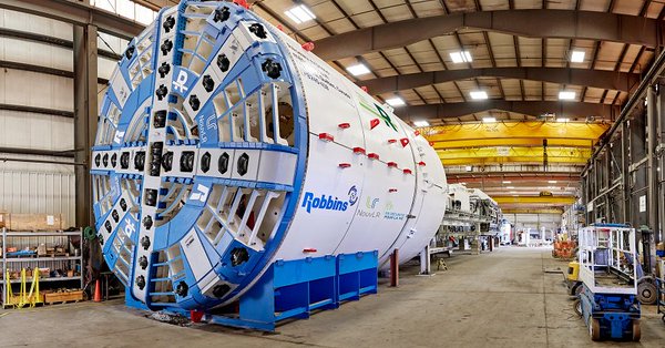
The tunnel boring machine has arrived
The The tunnel boring machine will dig a 3.5-km tunnel between the Technoparc and Montréal-Trudeau airport. The REM’s route will be underground in this area to protect the wetlands of the Technoparc and pass under the airport runways, more than 30 metres below the surface.
Given the huge size of the machine, it had to be delivered in pieces, requiring about 60 trucks. The next step is to assemble and test this specialized equipment, then drilling will begin in the coming months.
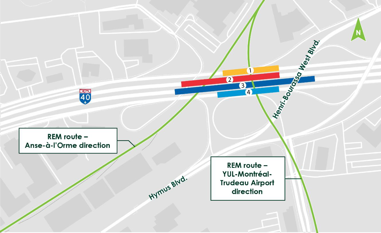
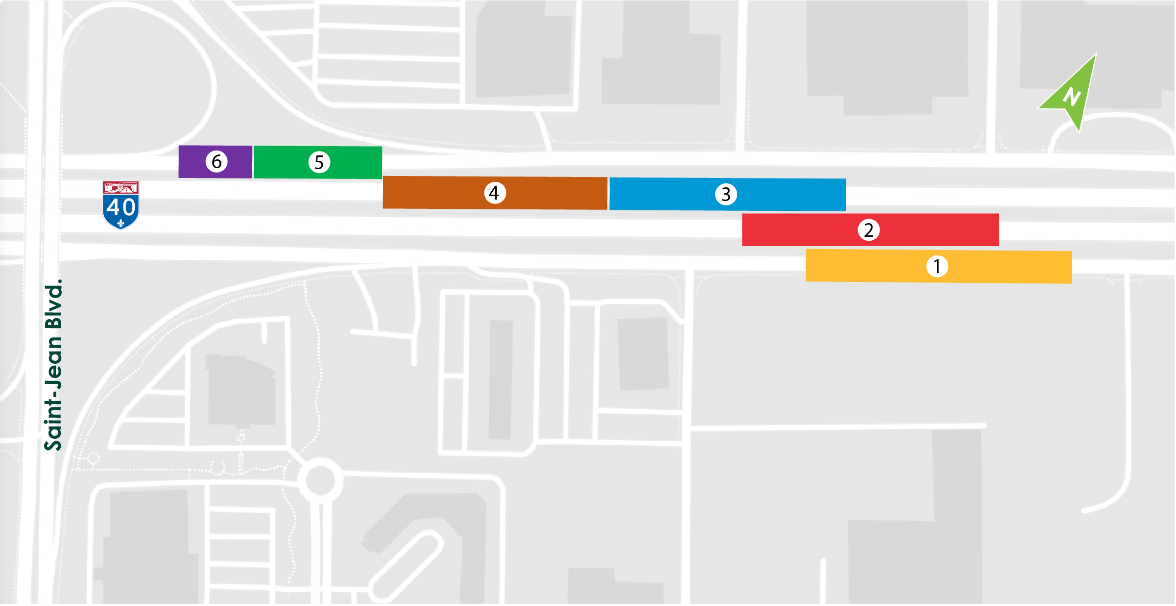
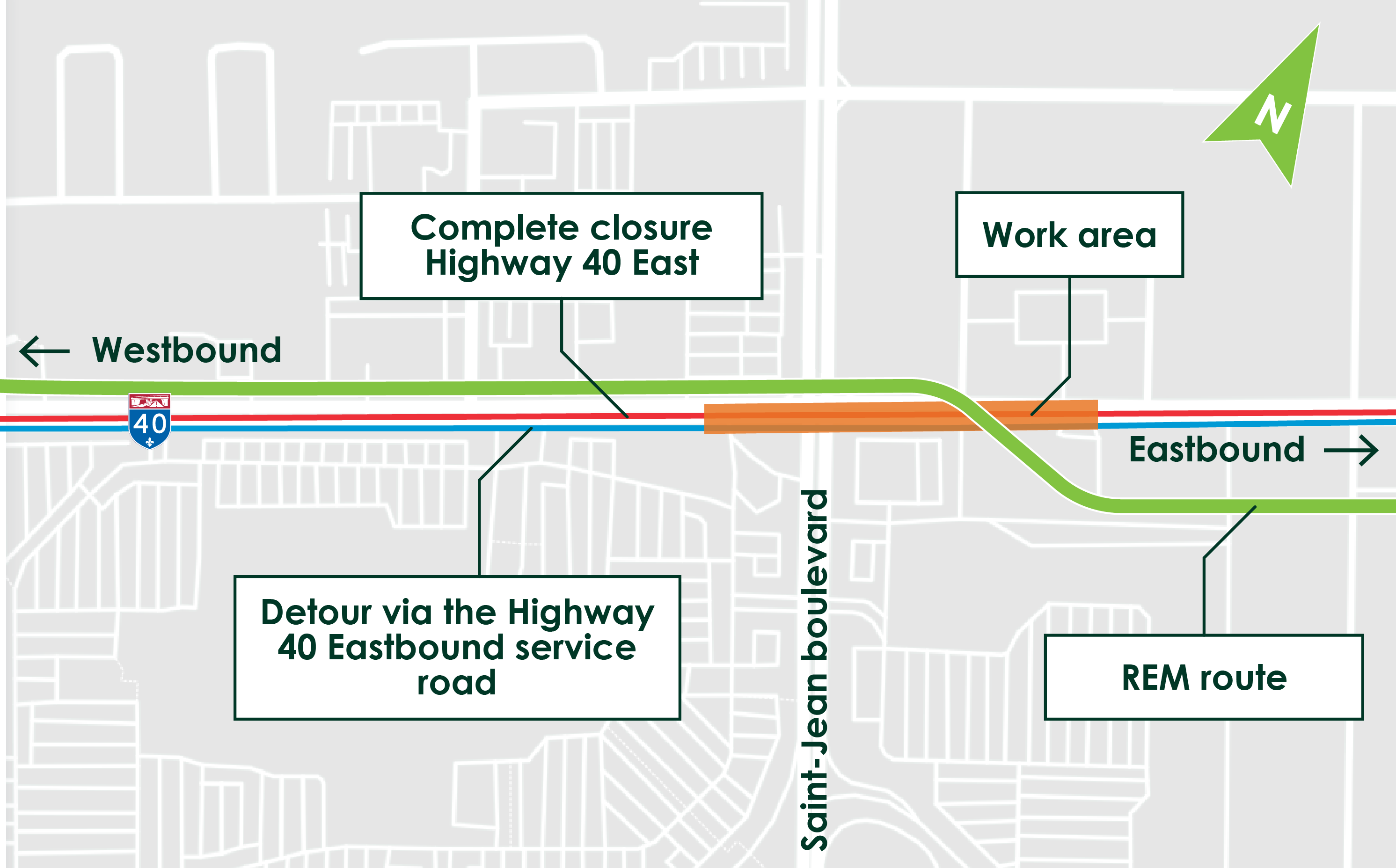
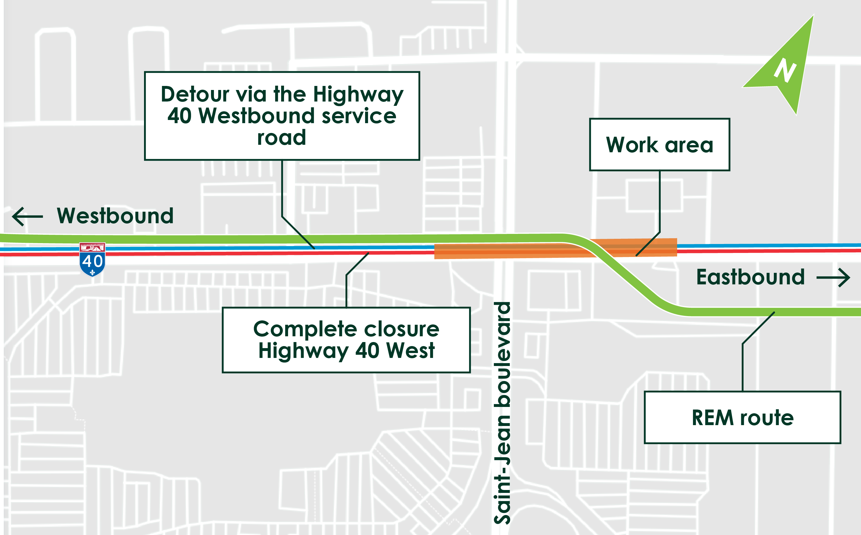
REM CROSSING OVER HIGHWAY 40 - OCTOBER 6 to 26
Nature of the work
To allow the REM’s elevated structure to be built on the West Island, traffic obstructions are planned starting October 6 on Highway 40 (A40) where it meets Henri-Bourassa Boulevard. During this operation, the REM deck will be installed above Highway 40. This “big span” operation will be done in multiple phases over a period of about one month (from October 6 to 26).
Work will be done only at night, except for the weekend of October 19 and 20 when daytime work will also be done. During the day, all roadways will remain open to traffic and users will be able to travel safely under the structure.
Impacts and mitigation measures
Segments of Highway 40 and the service roads are scheduled to be closed in the area as the installation of the REM crossing progresses above the highway.
October 6 to 10 *: Nighttime closure of the Higway 40 West service road
- 8 p.m. to 5 a.m.: Closure of the Henri-Bourassa Blvd. access ramp leading to the A40 West service road
- 10 p.m. to 5 a.m.: Closure of a segment of the westbound service road at Henri-Bourassa Boulevard
- Detour via Hymus Boulevard, up to Des Sources Boulevard and then back on to the A40.
- The A40 will be open during that period. However, please note that on October 9 and 10, the right lane of the A40 West will be closed from 10 p.m. to 5 a.m., which may cause slowdowns.
October 10 to 17*: Nighttime closure of Highway 40 West
- 11 p.m. to 7 a.m.: Closure of a segment of the A40 East at Exit 60.
- Closure of the access ramp before Chomedey Highway (see 1 on the map below).
- Closure of the access ramp coming from Chomedey Highway (see 2 on the map below).
- Detour via the westbound service road.
- The A40 East will be open during that period. However, please note that on October 15, 16 and 17, the left lane of the A40 East will be closed from 11 p.m. to 5 a.m., which may cause slowdowns.
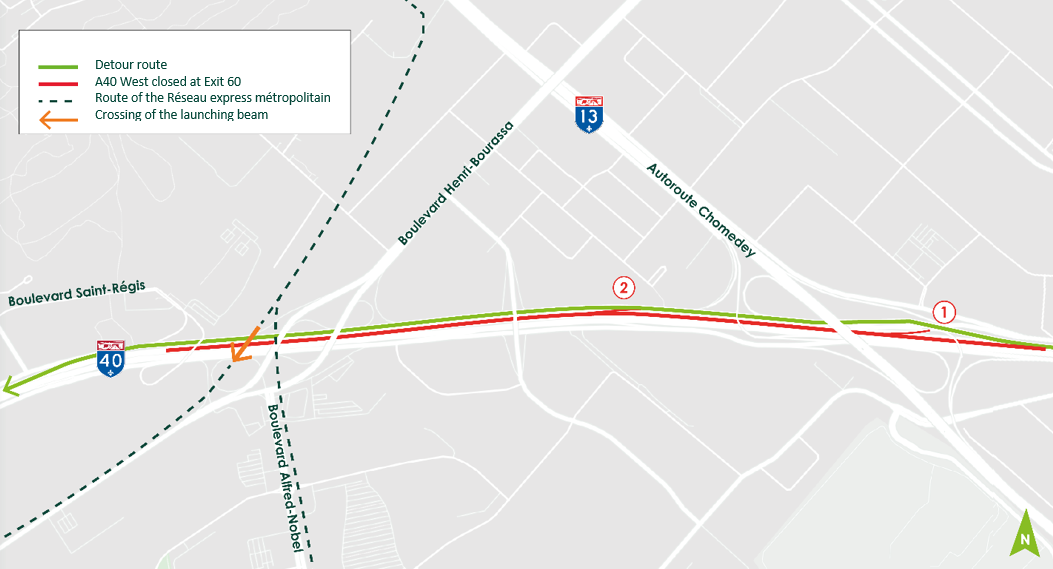
October 19 and 20*: Daytime closure of Highway 40 East for the entire weekend
- More details to come soon.
October 21 to 26*
- More details to come soon.
* Planned dates are subject to change according to work progress and weather conditions.
May 27, 2019
Destination REM : Access for all
(video available in French only)
One of the REM’s unique features is that the 26 stations will all offer universal access and be equipped with elevators. Beyond the stations, it was therefore important to also design rail cars accessible to everyone: users with functional limitations (motor or visual), families with strollers, travellers with suitcases, and so on. We developed a life-sized mode and tested it with people with reduced mobility so as to adapt specific elements and ensure access to everyone.
 REM Information Meeting
An information meeting regarding the REM will take place on Monday, April 29, at the Holiday Inn Pointe-Claire located at 6700 Trans-Canada Highway.
There will be an open house from 6:00 to 7:00 pm and an information session from 7:00 to 8 :00 pm during which you will be able to ask questions to the project experts as well as learn more details about the work to come in the West Island in 2019. For more information: https://rem.info/en/events/west-island-information-meeting
Traffic disruptions on H40 service road
-
Dates: Spring-Summer 2019 - Weekdays, day or night
-
Where: Highway 40 West service road between Charles E. Frosst St. and the Saint-Charles Boulevard access ramp
Nature of the work:
Work to relocate drinking water and stormwater pipes began March 19, and drilling for caissons continues. Traffic disruptions should be expected on the Highway 40 West service road between Charles E. Frosst Street and the Saint-Charles Boulevard access ramp. Appropriate signage will be installed to redirect traffic.
Planned work includes:
- Demolition of the centre median on Charles E. Frosst Street
- Drilling of an exploration well
- Installation of new pipes
Anticipated impacts and mitigation measures:
Just as for any construction site, work will have an impact on residents in the vicinity; they will be affected by noise, vibrations, dust, frequent use of trucks and traffic hindrances. Mitigation measures will be implemented to minimize the impacts. The REM project office and NouvLR consortium’s goal is to prevent or minimize impact on surrounding residents as much as possible and ensure safety by implementing all appropriate measures.
SCHEDULE OF THE WORKS
|
|
March 19 to March 219 a.m. to 3 p.m. |
Nature of the work :
|
March 25
|
Nature of the work :
|
April 1 to
|
Closure of the right turning lane connecting A40 service road with Charles E. Frosst Street Nature of the work :
|
April 8 to
|
Nature of the work :
|
April 10 to
|
Closure of the right turning lane connecting A40 service road with Charles E. Frosst Street Nature of the work :
|
Beginning of construction of the Réseau express métropolitain on the West Island
Date: Beginning in Fall 2018
From 6:30 a.m. to 7 p.m., 7 days a week, depending on work progress
Nature of the work:
The structure of the REM on the West Island will be elevated, from the Des Sources station to the Saint-Anne-de-Bellevue station. For work on the elevated portion of the route, pillars will need to be installed along the former Doney railway spur, as well as along Highway 40 at Fairview Pointe-Claire.
*Work will take place from 6:30 a.m. to 7 p.m. Work outside this time period may be necessary to mobilize and demobilize required equipment and to clean up the site.
Anticipated impacts and mitigation measures:
Just as for any construction site, work will have an impact on residents in the vicinity; they will be affected by noise, vibrations, dust, frequent use of trucks and traffic hindrances. Mitigation measures will be implemented to minimize the impacts. The REM project office and NouvLR consortium’s goal is to prevent or minimize impact on surrounding residents as much as possible and ensure safety by implementing all appropriate measures.
Sector 1: Between Jean-Yves Street and Morgan Avenue
Planned schedule ** |
|
|
Spring to Fall 2018 |
Relocation of public utilities |
|
Fall 2018 and 2019 |
Disturbance of first layer of soil |
|
Summer 2019 |
Construction of access roads |
|
Fall 2019 to Spring 2020 |
Construction of the elevated track superstructure (pile driving) |
|
Spring 2020 |
Construction of reinforced earth walls |
|
Spring 2020 to Fall 2020 |
Construction of the elevated track superstructure (columns) |
|
Fall 2020 |
Beginning of construction of the station |
|
Spring 2021 to Fall 2021 |
Construction of the elevated track superstructure (installation of segmented beams) |
|
Summer 2022 |
Restoration and final landscaping work |
Sector 2: Between Saint-Charles Boulevard and Jean-Yves Street
Planned schedule ** |
|
|
Fall 2018 to Fall 2019 |
Relocation of public utilities |
|
Fall 2018 |
Brush clearing and tree cutting |
|
Summer 2019 |
- Disturbance of first layer of soil |
|
Spring 2019 to Fall 2019 |
Construction of the elevated track superstructure (pile driving) |
|
Summer 2019 to Spring 2020 |
Construction of the elevated track superstructure (columns) |
|
Spring 2020 to Spring 2021 |
Construction of the elevated track superstructure (installation of segmented beams) |
|
Spring 2021 |
Beginning of construction of the station |
|
Spring 2022 |
Restoration and final landscaping work |
Sector 3: Between Saint-Jean and Saint-Charles Boulevards
Planned schedule ** |
|
|
Fall 2018 to Summer 2019 |
Relocation of public utilities |
|
Fall 2018 |
Brush clearing and tree cutting |
|
Fall 2018 |
- Disturbance of first layer of soil |
|
Fall 2018 to Spring 2019 AND |
Construction of the elevated track superstructure (pile driving) |
|
Winter 2019 to Summer 2019 AND |
Construction of the elevated track superstructure (columns) |
|
Spring 2020 |
Beginning of construction of the station |
|
Spring 2019 to Spring 2020 AND |
Construction of the elevated track superstructure (installation of segmented beams) |
|
Spring 2021 to Fall 2022 |
Restoration and final landscaping work |
**Work sequences are subject to change without notice.
News releases | Press Conference - July 10, 2018
- Le Gouvernement du Québec et la Ville de Montréal s'allient pour faciliter l'accès au REM et aux espaces verts de l'Ouest-de-l'Île (Available in French only)
- Map of the REM station in Kirkland
- Questions / answers (Available in French only)


Photos credits : Ville de Montréal
REM Works info
REM.info
Twitter @REMgrandmtl or Facebook