-739-384.png)
AlertsTo keep you informed of important messages from the city! |
2026-06-04
June 4, 2026 - Drinking water supply interruption AND boil water advisory for certain adresses on Beaubois St.Drinking water supply interruption AND boil water advisory for certain adresses on Beaubois St. on June 4 from 9 am to 3 pm.
June 4, 2026 - Drinking water supply interruption AND boil water advisory for certain adresses on Beaubois St.Notice to affected residences:
Please note that, as part of the rehabilitation work on Beaubois Street, the water supply to your household will be temporarily interrupted between 9 a.m. and 3 p.m. on Thursday, June 4, 2026. In preparation for this work, we recommend that you stock up on potable water to meet your consumption needs during this period. Preventative Boil-Water AdvisoryOnce water supply is restored, a preventative boil-water advisory will be in effect for a minimum of 48 hours and until further notice.
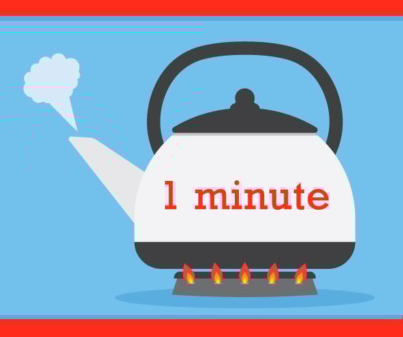
Please note that you must boil your tap water (bringing it to a bubbling boil) for at least 1 minute before drinking it, or use bottled water for:
YOU MAY USE UNBOILED TAP WATER TO :
Lifting of the boil-water advisoryWater samples will be collected from various locations and submitted for laboratory analysis. The boil-water advisory will be lifted once we receive the results of these tests, which requires a minimum of 48 hours. Please consult the Alerts section of the website for updates regarding the lifting of the boil water advisory. For additional information, please contact us by phone at 514-694-4100 or by email at [email protected]. Thank you for your understanding. |
|
2026-06-03
June 3, 2026 - Drinking water supply interruption AND boil water advisory for certain adresses on Beaubois St.Drinking water supply interruption AND boil water advisory for certain adresses on Beaubois St. on June 3 from 9 am to 3 pm.
June 3, 2026 - Drinking water supply interruption AND boil water advisory for certain adresses on Beaubois St.Notice to affected residences:
Please note that, as part of the rehabilitation work on Beaubois Street, the water supply to your household will be temporarily interrupted between 9 a.m. and 3 p.m. on Wednesday, June 3, 2026. In preparation for this work, we recommend that you stock up on potable water to meet your consumption needs during this period. Preventative Boil-Water AdvisoryOnce water supply is restored, a preventative boil-water advisory will be in effect for a minimum of 48 hours and until further notice.
Please note that you must boil your tap water (bringing it to a bubbling boil) for at least 1 minute before drinking it, or use bottled water for:
YOU MAY USE UNBOILED TAP WATER TO :
Lifting of the boil-water advisoryWater samples will be collected from various locations and submitted for laboratory analysis. The boil-water advisory will be lifted once we receive the results of these tests, which requires a minimum of 48 hours. Please consult the Alerts section of the website for updates regarding the lifting of the boil water advisory. For additional information, please contact us by phone at 514-694-4100 or by email at [email protected]. Thank you for your understanding. |
|
|
2026-06-01
June 1st, 2026 - Drinking water supply interruption AND boil water advisory for Beaubois St.Drinking water supply interruption AND boil water advisory for Beaubois St. on June 1st from 9 am to 3 pm.
June 1st, 2026 - Drinking water supply interruption AND boil water advisory for Beaubois St.Notice to affected residences:
Please note that, as part of the rehabilitation work on Beaubois Street, the water supply to your household will be temporarily interrupted between 9 a.m. and 3 p.m. on Monday, June 1st, 2026. In preparation for this work, we recommend that you stock up on potable water to meet your consumption needs during this period. Preventative Boil-Water AdvisoryOnce water supply is restored, a preventative boil-water advisory will be in effect for a minimum of 48 hours and until further notice.
Please note that you must boil your tap water (bringing it to a bubbling boil) for at least 1 minute before drinking it, or use bottled water for:
YOU MAY USE UNBOILED TAP WATER TO :
Lifting of the boil-water advisoryWater samples will be collected from various locations and submitted for laboratory analysis. The boil-water advisory will be lifted once we receive the results of these tests, which requires a minimum of 48 hours. Please consult the Alerts section of the website for updates regarding the lifting of the boil water advisory. For additional information, please contact us by phone at 514-694-4100 or by email at [email protected]. Thank you for your understanding. |
|
Works InfoStay informed about the work being carried out in the city, whether it involves road repairs, infrastructure maintenance, work on the water network, or park redevelopment. For any questions or to report an issue related to the work, please call 514-694-4100. |
2026-06-03
Asphalt paving work at Ecclestone ParkAsphalt paving work at Ecclestone Park from June 3 to 9, 2026
Asphalt paving work at Ecclestone ParkDates: June 3 to 9, 2026 Nature of work: Excavation and asphalt resurfacing Location: Ecclestone Park (tennis court access path) Expected impacts: No major disruptions are anticipated. Access to the park chalet and tennis court will be maintained throughout the duration of the work.
|
|
2026-06-01
Road Reconstruction – Beaubois StreetRoad Reconstruction on Beaubois Street. More details...
|
|
|
2026-05-19
Watermain Rehabilitation work - Calais StreetWatermain rehabilitation work by structural lining
|
|
|
2026-05-04
Watermain Rehabilitation work - Montague, Charlevoix & Sutton streetsWatermain rehabilitation work by structural lining
|
 RECOMMENDATIONS:
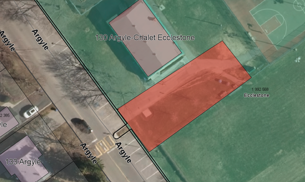

Message from the Mayor
It gives me great pleasure to welcome you to YOUR new website, the ideal location where to find complete and detailed information on services, programs and events available to YOU.
With its newly redesigned look and fresh content, the new website is easier to navigate and offers a more dynamic and user-friendly platform for you to access the most current information at the click of a mouse.
In addition to offering many online services and new interactive features, site navigation was designed to provide citizens with an optimal viewing experience — easy reading and navigation no matter which device is used, from desktop computer monitors to mobile phones and tablets. The new website thus reflects our ongoing commitment for consistent improvement of accessibility to municipal services for our citizens.
Without further ado, I now invite you to browse through your new portal and encourage you to visit the site regularly to stay abreast of the latest news and upcoming events.
Happy surfing and be sure to visit YOUR interactive property!
Michel Gibson
Mayor